
Tempoal topographic map
Click on the map to display elevation.
About this map
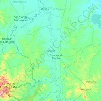
Name: Tempoal topographic map, elevation, terrain.
Location: Tempoal, Veracruz, Mexico (21.37859 -98.64370 21.72183 -98.08086)
Average elevation: 81 m
Minimum elevation: 10 m
Maximum elevation: 563 m
Other topographic maps
Click on a map to view its topography, its elevation and its terrain.
Córdoba
Córdoba is located in the center of the state of Veracruz, at 18º51'30" north latitude and 96º55'51" west longitude. It lies between the hills of Matlaquiahitl and Tepixtepec, at an elevation of 817 meters (2,680 feet) above mean sea level.
Average elevation: 1,030 m
Fraccionamiento Ciudad Olmeca
Mexico > Veracruz > Coatzacoalcos > Fraccionamiento Ciudad Olmeca
Average elevation: 6 m