
Thank you for supporting this site ❤️
Make a donation
Make a donation
Gear up for your next adventure:
As an Amazon Associate, this site earns from qualifying purchases at no extra cost to you.
Tlalnepantla topographic map
Click on the map to display elevation.
Thank you for supporting this site ❤️
Make a donation
Make a donation
Gear up for your next adventure:
As an Amazon Associate, this site earns from qualifying purchases at no extra cost to you.
About this map
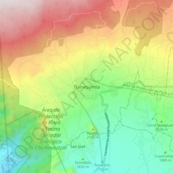
Name: Tlalnepantla topographic map, elevation, terrain.
Location: Tlalnepantla, Morelos, Mexico (18.96850 -99.03712 19.04850 -98.95712)
Average elevation: 2,183 m
Minimum elevation: 1,576 m
Maximum elevation: 3,030 m
Thank you for supporting this site ❤️
Make a donation
Make a donation
Gear up for your next adventure:
As an Amazon Associate, this site earns from qualifying purchases at no extra cost to you.