
Make a donation
Gear up for your next adventure:
As an Amazon Associate, this site earns from qualifying purchases at no extra cost to you.
Lerdo de Tejada topographic map
Click on the map to display elevation.
Make a donation
Gear up for your next adventure:
As an Amazon Associate, this site earns from qualifying purchases at no extra cost to you.
About this map
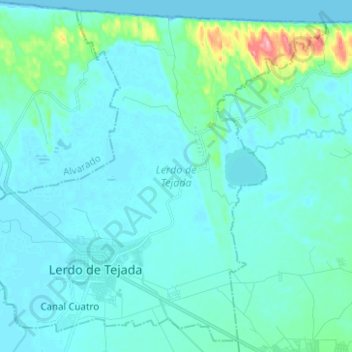
Name: Lerdo de Tejada topographic map, elevation, terrain.
Location: Lerdo de Tejada, Veracruz, Mexico (18.60381 -95.56144 18.71482 -95.43680)
Average elevation: 15 m
Minimum elevation: -2 m
Maximum elevation: 132 m
Make a donation
Gear up for your next adventure:
As an Amazon Associate, this site earns from qualifying purchases at no extra cost to you.
Other topographic maps
Click on a map to view its topography, its elevation and its terrain.
Córdoba
Córdoba is located in the center of the state of Veracruz, at 18º51'30" north latitude and 96º55'51" west longitude. It lies between the hills of Matlaquiahitl and Tepixtepec, at an elevation of 817 meters (2,680 feet) above mean sea level.
Average elevation: 1,030 m
Make a donation
Gear up for your next adventure:
As an Amazon Associate, this site earns from qualifying purchases at no extra cost to you.
Fraccionamiento Ciudad Olmeca
Mexico > Veracruz > Coatzacoalcos > Fraccionamiento Ciudad Olmeca
Average elevation: 6 m