
Make a donation
Gear up for your next adventure:
As an Amazon Associate, this site earns from qualifying purchases at no extra cost to you.
Gorleston-on-Sea topographic map
Click on the map to display elevation.
Make a donation
Gear up for your next adventure:
As an Amazon Associate, this site earns from qualifying purchases at no extra cost to you.
About this map
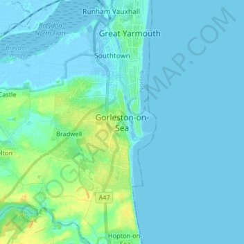
Name: Gorleston-on-Sea topographic map, elevation, terrain.
Average elevation: 4 m
Minimum elevation: -5 m
Maximum elevation: 23 m
Make a donation
Gear up for your next adventure:
As an Amazon Associate, this site earns from qualifying purchases at no extra cost to you.
Other topographic maps
Click on a map to view its topography, its elevation and its terrain.
Make a donation
Gear up for your next adventure:
As an Amazon Associate, this site earns from qualifying purchases at no extra cost to you.
South Lopham
United Kingdom > England > Norfolk > Breckland District > South Lopham
Average elevation: 36 m
Make a donation
Gear up for your next adventure:
As an Amazon Associate, this site earns from qualifying purchases at no extra cost to you.
Ringstead
United Kingdom > England > Norfolk > King's Lynn and West Norfolk > Ringstead
Average elevation: 37 m
Make a donation
Gear up for your next adventure:
As an Amazon Associate, this site earns from qualifying purchases at no extra cost to you.
Brettenham Heath - Open Access Land
United Kingdom > England > Norfolk > Breckland District > Brettenham
Average elevation: 40 m
Make a donation
Gear up for your next adventure:
As an Amazon Associate, this site earns from qualifying purchases at no extra cost to you.
Make a donation
Gear up for your next adventure:
As an Amazon Associate, this site earns from qualifying purchases at no extra cost to you.
Make a donation
Gear up for your next adventure:
As an Amazon Associate, this site earns from qualifying purchases at no extra cost to you.
Make a donation
Gear up for your next adventure:
As an Amazon Associate, this site earns from qualifying purchases at no extra cost to you.
Make a donation
Gear up for your next adventure:
As an Amazon Associate, this site earns from qualifying purchases at no extra cost to you.
Weasenham All Saints
United Kingdom > England > Norfolk > Breckland District > Weasenham
Average elevation: 71 m
Make a donation
Gear up for your next adventure:
As an Amazon Associate, this site earns from qualifying purchases at no extra cost to you.
Grimston
United Kingdom > England > Norfolk > King's Lynn and West Norfolk > Grimston
Average elevation: 30 m
Make a donation
Gear up for your next adventure:
As an Amazon Associate, this site earns from qualifying purchases at no extra cost to you.
Make a donation
Gear up for your next adventure:
As an Amazon Associate, this site earns from qualifying purchases at no extra cost to you.
Downham Market
United Kingdom > England > Norfolk > King's Lynn and West Norfolk
Average elevation: 20 m
Make a donation
Gear up for your next adventure:
As an Amazon Associate, this site earns from qualifying purchases at no extra cost to you.
Terrington St. Clement
United Kingdom > England > Norfolk > King's Lynn and West Norfolk
Average elevation: 2 m
Make a donation
Gear up for your next adventure:
As an Amazon Associate, this site earns from qualifying purchases at no extra cost to you.
Wymondham
United Kingdom > England > Norfolk > South Norfolk
Wymondham's topography is marked by its river meadow and flat, low-lying agricultural landscape, much like the rest of East Anglia. The parish has an area of 17.11 square miles (44.31 km2). The geology is based on chalk, with a layer of boulder clay laid down in the last ice age. The River Tiffey, flowing…
Average elevation: 43 m
Make a donation
Gear up for your next adventure:
As an Amazon Associate, this site earns from qualifying purchases at no extra cost to you.
Make a donation
Gear up for your next adventure:
As an Amazon Associate, this site earns from qualifying purchases at no extra cost to you.
Make a donation
Gear up for your next adventure:
As an Amazon Associate, this site earns from qualifying purchases at no extra cost to you.
Strumpshaw
United Kingdom > England > Norfolk > Broadland
The village lies a little distance from the river, on the slopes of Strumpshaw Hill, the highest area of land in the Norfolk Broads. Because of its elevation, Strumpshaw hosted, from the late 1790s through to the mid-1810s, a repeater station in the shutter telegraph chain linking the Admiralty in London with…
Average elevation: 11 m
Make a donation
Gear up for your next adventure:
As an Amazon Associate, this site earns from qualifying purchases at no extra cost to you.
Make a donation
Gear up for your next adventure:
As an Amazon Associate, this site earns from qualifying purchases at no extra cost to you.
Make a donation
Gear up for your next adventure:
As an Amazon Associate, this site earns from qualifying purchases at no extra cost to you.
Make a donation
Gear up for your next adventure:
As an Amazon Associate, this site earns from qualifying purchases at no extra cost to you.
Make a donation
Gear up for your next adventure:
As an Amazon Associate, this site earns from qualifying purchases at no extra cost to you.
Old Hunstanton
United Kingdom > England > Norfolk > King's Lynn and West Norfolk
Average elevation: 17 m
Make a donation
Gear up for your next adventure:
As an Amazon Associate, this site earns from qualifying purchases at no extra cost to you.
Holme next the Sea
United Kingdom > England > Norfolk > King's Lynn and West Norfolk
Average elevation: 10 m
Tilney All Saints
United Kingdom > England > Norfolk > King's Lynn and West Norfolk
Average elevation: 3 m
Make a donation
Gear up for your next adventure:
As an Amazon Associate, this site earns from qualifying purchases at no extra cost to you.
Make a donation
Gear up for your next adventure:
As an Amazon Associate, this site earns from qualifying purchases at no extra cost to you.
Heydon
United Kingdom > England > Norfolk > Broadland
By the village green there is an 18th-century public house – The Earle Arms – which is grade II listed and has a "Regionally Important Historic Interior". It was until circa 1845 called the Lion and Lamb. It is believed that a pub has existed at this location since the 16th century, and was a coaching inn.…
Average elevation: 44 m
Make a donation
Gear up for your next adventure:
As an Amazon Associate, this site earns from qualifying purchases at no extra cost to you.