Geolocate

Taverham topographic map

Click on the map to display elevation.

About this map

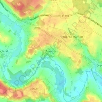
Name: Taverham topographic map, elevation, terrain.

Location: Taverham, Broadland, Norfolk, England, United Kingdom (52.66000 1.16043 52.70269 1.21753)

Average elevation: 25 m

Minimum elevation: 2 m

Maximum elevation: 54 m

Gear up for your next adventure:

🔦LED Headtorch - Bright and durable light for night activities
🧭GPS Handheld Device - Reliable GPS navigation for outdoor adventures
👟Sport Hiking Sandals - Breathable footwear for water crossings and camp rest
🧼Travel Hand Sanitizer - Keep hands clean when water is scarce
📷Outdoor Action Camera - Capture high-elevation views and rugged adventures

As an Amazon Associate, this site earns from qualifying purchases at no extra cost to you.