Geolocate

Diss topographic map

Click on the map to display elevation.

About this map

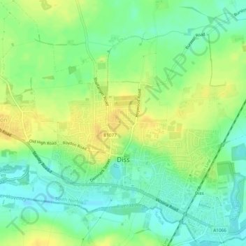
Name: Diss topographic map, elevation, terrain.

Location: Diss, Norfolk, England, United Kingdom (52.36712 1.09617 52.39522 1.14351)

Average elevation: 35 m

Minimum elevation: 22 m

Maximum elevation: 47 m

Other topographic maps

Click on a map to view its topography, its elevation and its terrain.

Norwich

United Kingdom > England > Norfolk > Norwich

Average elevation: 29 m

Southgate

United Kingdom > England > Norfolk > Broadland > Cawston

Average elevation: 42 m

Limpenhoe

United Kingdom > England > Norfolk > Broadland

Average elevation: 7 m

Ashwicken

United Kingdom > England > Norfolk > Ashwicken

Average elevation: 17 m

Bradfield

United Kingdom > England > Norfolk > North Norfolk > Bradfield

Average elevation: 32 m

Snipe Lake

United Kingdom > England > Norfolk > South Norfolk > Costessey

Average elevation: 19 m

Gear up for your next adventure:

🧥Ultralight Puffy Jacket - Maximum warmth that packs down to the size of an orange
🧥Waterproof Jacket - Lightweight rain jackets for hiking and outdoor activities
🧥Thermal Fleece Jacket - Versatile insulation for changing mountain temperatures
💡Portable Camping Lamp - Rechargeable lamp for campsite lighting
🛶Kayak Dry Bag - Waterproof storage for kayaking adventures

As an Amazon Associate, this site earns from qualifying purchases at no extra cost to you.