Geolocate

Yelverton topographic map

Click on the map to display elevation.

About this map

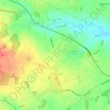
Name: Yelverton topographic map, elevation, terrain.

Location: Yelverton, South Norfolk, Norfolk, England, United Kingdom (52.56637 1.36819 52.58364 1.40002)

Average elevation: 35 m

Minimum elevation: 10 m

Maximum elevation: 61 m

Gear up for your next adventure:

🧥Packable Rain Jacket - Breathable waterproof layer for unpredictable weather
🧴Insect Repellent - Protect yourself from bugs during outdoor adventures
🥤Collapsible Travel Cup - Saves space and weight in your mess kit
🦟Insect Repellent - Keep mosquitoes and black flies away in wooded areas
👟Leg Gaiters - Keep debris, mud, and snow out of your boots

As an Amazon Associate, this site earns from qualifying purchases at no extra cost to you.