Geolocate

Riverside topographic map

Click on the map to display elevation.

About this map

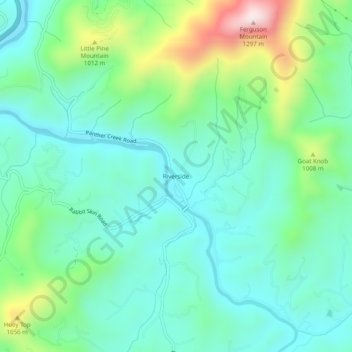
Name: Riverside topographic map, elevation, terrain.

Location: Riverside, Haywood County, North Carolina, United States (35.59816 -82.98792 35.63816 -82.94792)

Average elevation: 856 m

Minimum elevation: 715 m

Maximum elevation: 1,267 m

Other topographic maps

Click on a map to view its topography, its elevation and its terrain.

Canton

United States > North Carolina > Haywood County

Average elevation: 942 m

Gear up for your next adventure:

🧥Thermal Fleece Jacket - Versatile insulation for changing mountain temperatures
🔦LED Headlamp - Hands-free lighting for early morning starts or late finishes
🧢Hiking Hat - Sun-protective and breathable hats for long treks
🧥Softshell Jacket - Windproof and breathable jacket for hiking
🏕️Camping Hammock - Integrated protection for sleeping between trees

As an Amazon Associate, this site earns from qualifying purchases at no extra cost to you.