
Lincoln Heights topographic map
Interactive map
Click on the map to display elevation.
About this map
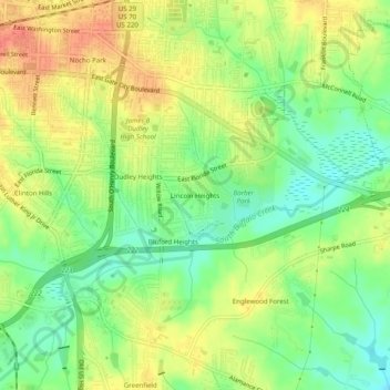
Name: Lincoln Heights topographic map, elevation, terrain.
Average elevation: 234 m
Minimum elevation: 208 m
Maximum elevation: 260 m
Other topographic maps
Click on a map to view its topography, its elevation and its terrain.
Cumberland
United States > North Carolina > Guilford County > Greensboro > Cumberland
Cumberland, Greensboro, Guilford County, North Carolina, 27401, United States
Average elevation: 244 m
Dellwood Park
United States > North Carolina > Guilford County > Greensboro > Dellwood Park
Dellwood Park, Greensboro, Guilford County, North Carolina, 27427, United States
Average elevation: 245 m