
President Roxas topographic map
Click on the map to display elevation.
About this map
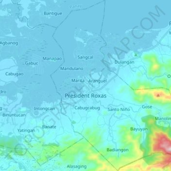
Name: President Roxas topographic map, elevation, terrain.
Location: President Roxas, Capiz, Western Visayas, 5803, Philippines (11.37082 122.89699 11.50451 123.00783)
Average elevation: 55 m
Minimum elevation: -3 m
Maximum elevation: 740 m
Other topographic maps
Click on a map to view its topography, its elevation and its terrain.
Mount Nangtud
Philippines > Capiz > Jamindan
Mount Nangtud is the second highest peak on the island of Panay, in the Philippines and third highest mountain in the Visayas, after Mount Kanlaon and Mount Madja-as. With an elevation of 2,074 m (6,804 ft) above sea level, it is located geographically within Jamindan, Capiz bordering with Barbaza, Antique.…
Average elevation: 1,578 m