Geolocate

Panay River topographic map

Click on the map to display elevation.

About this map

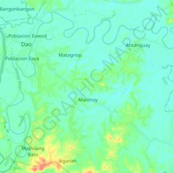
Name: Panay River topographic map, elevation, terrain.

Location: Panay River, Dao, Capiz, Western Visayas, 5810, Philippines (11.34902 122.67755 11.40640 122.74538)

Average elevation: 18 m

Minimum elevation: 4 m

Maximum elevation: 64 m

Other topographic maps

Click on a map to view its topography, its elevation and its terrain.

Poblacion Ilaya

Philippines > Capiz > Dao

Average elevation: 16 m

Lumbaya

Philippines > Capiz > Dao > Nasunogan

Average elevation: 21 m

Gear up for your next adventure:

🥾Light Hiking Boots - Lightweight and comfortable boots for day hikes
🧤Rechargeable Heated Gloves - Extreme warmth for Canadian winter expeditions
🥾Hiking Leggings - Comfortable leggings for outdoor activities
🧦Merino Wool Socks - Moisture-wicking comfort for long-distance hiking
💡Portable Camping Lamp - Rechargeable lamp for campsite lighting

As an Amazon Associate, this site earns from qualifying purchases at no extra cost to you.