
Make a donation
Gear up for your next adventure:
As an Amazon Associate, this site earns from qualifying purchases at no extra cost to you.
Mount Nangtud topographic map
Click on the map to display elevation.
Make a donation
Gear up for your next adventure:
As an Amazon Associate, this site earns from qualifying purchases at no extra cost to you.
Mount Nangtud
Mount Nangtud is the second highest peak on the island of Panay, in the Philippines and third highest mountain in the Visayas, after Mount Kanlaon and Mount Madja-as. With an elevation of 2,074 m (6,804 ft) above sea level, it is located geographically within Jamindan, Capiz bordering with Barbaza, Antique. Mount Nangtud is famous for its "sea of clouds" and rich for its diverse flora and fauna and mossy forest. It is part of the Central Panay Mountain Range, the longest and largest mountain range in Panay and Western Visayas.
Make a donation
Gear up for your next adventure:
As an Amazon Associate, this site earns from qualifying purchases at no extra cost to you.
About this map
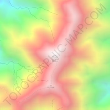
Name: Mount Nangtud topographic map, elevation, terrain.
Location: Mount Nangtud, Jamindan, Capiz, Western Visayas, Philippines (11.26787 122.20595 11.26797 122.20605)
Average elevation: 1,578 m
Minimum elevation: 888 m
Maximum elevation: 2,034 m
Make a donation
Gear up for your next adventure:
As an Amazon Associate, this site earns from qualifying purchases at no extra cost to you.
Other topographic maps
Click on a map to view its topography, its elevation and its terrain.