Geolocate

Tabuc topographic map

Click on the map to display elevation.

About this map

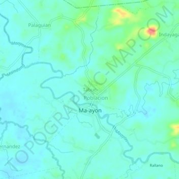
Name: Tabuc topographic map, elevation, terrain.

Location: Tabuc, Ma-ayon, Capiz, Western Visayas, Philippines (11.37178 122.76106 11.41178 122.80106)

Average elevation: 17 m

Minimum elevation: 3 m

Maximum elevation: 76 m

Other topographic maps

Click on a map to view its topography, its elevation and its terrain.

Barangay Tuburan

Philippines > Capiz > Ma-ayon

Average elevation: 64 m

Maayon

Philippines > Capiz > Ma-ayon > Rallano

Average elevation: 25 m

Gear up for your next adventure:

💧Hydration Bladder - Hands-free hydration solution for long treks
🥾Trail Running Shoes - Lightweight and durable shoes for trail running
🔪Outdoor Multitool - Versatile tool for repairs and food prep in the wild
🎒Backpack Rain Cover - External shield to keep your entire pack dry
🛶Waterproof Dry Bags - Keep electronics and clothes dry during river crossings

As an Amazon Associate, this site earns from qualifying purchases at no extra cost to you.