Geolocate

Pandan topographic map

Click on the map to display elevation.

About this map

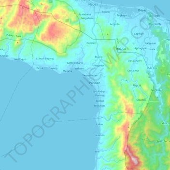
Name: Pandan topographic map, elevation, terrain.

Location: Pandan, Antique, Western Visayas, 5712, Philippines (11.61314 121.93865 11.82012 122.17865)

Average elevation: 136 m

Minimum elevation: -1 m

Maximum elevation: 1,054 m

Gear up for your next adventure:

🛁Quick-Dry Microfiber Towel - Space-saving towel that dries rapidly on the move
🧊Insulated Water Bottle - Keeps drinks cold in summer and prevents freezing in winter
🧢Hiking Sun Hat - Wide-brimmed protection for exposed mountain ridges
🔭Compact Binoculars - Lightweight optics for scouting trails and wildlife
🥾Hiking Shorts - Breathable shorts suitable for summer hikes

As an Amazon Associate, this site earns from qualifying purchases at no extra cost to you.