Geolocate

Caridad topographic map

Click on the map to display elevation.

About this map

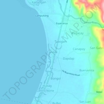
Name: Caridad topographic map, elevation, terrain.

Location: Caridad, Culasi, Antique, Western Visayas, Philippines (11.42719 122.04224 11.46719 122.08224)

Average elevation: 14 m

Minimum elevation: -1 m

Maximum elevation: 144 m

Gear up for your next adventure:

🔨Vehicle Emergency Tool - Safety tool for remote road trips to trailheads
Lightweight Camping Tent - Portable shelter optimized for Canadian backcountry camping
🥾Approach Boots - Comfortable boots for hiking and climbing approaches
🧴Waterproofing Spray - Restore the DWR coating on jackets and tents
💡LED Headlamp - Hands-free illumination for night hiking and camping

As an Amazon Associate, this site earns from qualifying purchases at no extra cost to you.