Geolocate

Malumpati topographic map

Click on the map to display elevation.

About this map

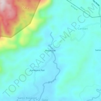
Name: Malumpati topographic map, elevation, terrain.

Location: Malumpati, Pandan, Antique, Western Visayas, Philippines (11.74642 122.05640 11.78642 122.09640)

Average elevation: 95 m

Minimum elevation: 0 m

Maximum elevation: 497 m

Gear up for your next adventure:

🧢Beanie Hat - Keep your head warm in cold weather
Camping Coffee Maker - Brew fresh coffee anywhere on the topographic map
🥾Hiking Boots - Sturdy boots providing ankle support and traction on rugged trails
🥾Trekking Poles - Adjustable trekking poles to reduce knee stress and improve stability
🩹Moleskin Blister Pads - Direct protection for painful foot pressure points

As an Amazon Associate, this site earns from qualifying purchases at no extra cost to you.