Geolocate

Canipayan topographic map

Click on the map to display elevation.

About this map

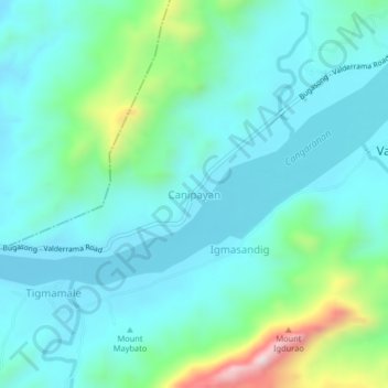
Name: Canipayan topographic map, elevation, terrain.

Location: Canipayan, Valderrama, Antique, Western Visayas, Philippines (10.97732 122.08675 11.01732 122.12675)

Average elevation: 146 m

Minimum elevation: 30 m

Maximum elevation: 628 m

Gear up for your next adventure:

🥾Waterproof Hiking Boots - Boots keeping your feet dry in wet conditions
🛏️Sleeping Bag - Warm and compact sleeping bags for outdoor camping
🔦LED Headtorch - Bright and durable light for night activities
🧰Survival Kit - Essential gear for emergencies in the wilderness
🔦LED Flashlight - Powerful and long-lasting flashlight for camping and emergencies

As an Amazon Associate, this site earns from qualifying purchases at no extra cost to you.