
Saint John River topographic map
Interactive map
Click on the map to display elevation.
About this map
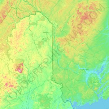
Name: Saint John River topographic map, elevation, terrain.
Location: Saint John River, New Brunswick, Canada (45.25997 -69.88389 47.36029 -66.02145)
Average elevation: 224 m
Minimum elevation: -3 m
Maximum elevation: 1,439 m
New Brunswick trails, hiking, mountain biking, running and outdoor activities
Other topographic maps
Click on a map to view its topography, its elevation and its terrain.
Edmundston
Canada > New Brunswick > Edmundston
Edmundston has a downhill skiing facility in the city at Mont Farlagne. This facility has 3 lifts, a t-bar, a double chair, and a quad chair. It has 14 trails and an elevation of 690 feet. Snowmaking is available. Five trails are lit for night skiing.
Average elevation: 256 m
Saint Andrews
Canada > New Brunswick > Charlotte County > Town of Saint Andrews
Average elevation: 7 m
Saint-Quentin
Canada > New Brunswick > Saint Quentin Parish
Saint-Quentin is in the Restigouche region of the Appalachian Mountains, 50 kilometres west of Mount Carleton, the province's highest elevation.
Average elevation: 284 m