
Make a donation
Gear up for your next adventure:
As an Amazon Associate, this site earns from qualifying purchases at no extra cost to you.
Samtskhe-Javakheti topographic map
Click on the map to display elevation.
Make a donation
Gear up for your next adventure:
As an Amazon Associate, this site earns from qualifying purchases at no extra cost to you.
About this map
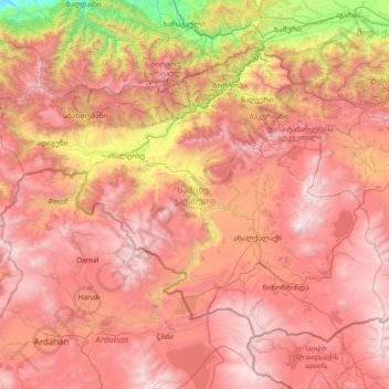
Name: Samtskhe-Javakheti topographic map, elevation, terrain.
Location: Samtskhe-Javakheti, Georgia (41.10933 42.49199 41.94390 43.96659)
Average elevation: 1,818 m
Minimum elevation: 122 m
Maximum elevation: 3,277 m
Make a donation
Gear up for your next adventure:
As an Amazon Associate, this site earns from qualifying purchases at no extra cost to you.
Other topographic maps
Click on a map to view its topography, its elevation and its terrain.
Caucasus Mountains
Georgia > Mtskheta-Mtianeti > Dusheti Municipality > Chalisopeli
The climate of the Caucasus varies both vertically (according to elevation) and horizontally (by latitude and location). Temperature generally decreases as elevation rises. Average annual temperature in Sukhumi, Abkhazia at sea level is 15 °C (59 °F) while on the slopes of Mt.Kazbek at an elevation of 3,700…
Average elevation: 2,188 m
Make a donation
Gear up for your next adventure:
As an Amazon Associate, this site earns from qualifying purchases at no extra cost to you.
Make a donation
Gear up for your next adventure:
As an Amazon Associate, this site earns from qualifying purchases at no extra cost to you.
Make a donation
Gear up for your next adventure:
As an Amazon Associate, this site earns from qualifying purchases at no extra cost to you.
Tsalenjikha
Georgia > Samegrelo-Upper Svaneti > Tsalenjikha Municipality > Tsalenjikha
Average elevation: 241 m
Chkhorotsku
Georgia > Samegrelo-Upper Svaneti > Chkhorotsqu Municipality > Chkhorotsku
Average elevation: 201 m
Sartichala
Georgia > Lower Kartli > Gardabani Municipality
Sartichala is situated along the west bank of the Iori (river), atop the Iori Plateau, and lies at an elevation of 680 meters above sea level. The village is located approximately 34 kilometers east of Georgia's capital, Tbilisi and has the population of 6,009 (2014 census).
Average elevation: 707 m
Make a donation
Gear up for your next adventure:
As an Amazon Associate, this site earns from qualifying purchases at no extra cost to you.