
Thank you for supporting this site ❤️
Make a donation
Make a donation
Gear up for your next adventure:
As an Amazon Associate, this site earns from qualifying purchases at no extra cost to you.
Tskaltubo topographic map
Click on the map to display elevation.
Thank you for supporting this site ❤️
Make a donation
Make a donation
Gear up for your next adventure:
As an Amazon Associate, this site earns from qualifying purchases at no extra cost to you.
About this map
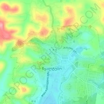
Name: Tskaltubo topographic map, elevation, terrain.
Location: Tskaltubo, Tskaltubo Municipality, Imereti, 5400, Georgia (42.31573 42.59168 42.34365 42.62722)
Average elevation: 135 m
Minimum elevation: 91 m
Maximum elevation: 212 m
Thank you for supporting this site ❤️
Make a donation
Make a donation
Gear up for your next adventure:
As an Amazon Associate, this site earns from qualifying purchases at no extra cost to you.