
Gldani topographic map
Click on the map to display elevation.
About this map
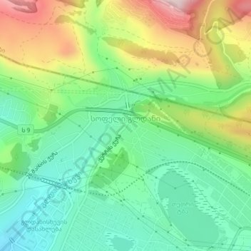
Name: Gldani topographic map, elevation, terrain.
Location: Gldani, Georgia (41.81709 44.81416 41.82932 44.84597)
Average elevation: 619 m
Minimum elevation: 484 m
Maximum elevation: 862 m
Other topographic maps
Click on a map to view its topography, its elevation and its terrain.
Zugdidi
Georgia > Samegrelo-Upper Svaneti > Zugdidi Municipality
Zugdidi (Georgian: ზუგდიდი; Mingrelian: ზუგდიდი or ზუგიდი) is a city in the western Georgian historical province of Samegrelo (Mingrelia). It is situated in the north-west of that province. The city is located 318 kilometres west of Tbilisi, 30 km from the Black Sea…
Average elevation: 111 m
Kutaisi
Kutaisi is located along both banks of the Rioni River. The city lies at an elevation of 125–300 metres (410–984 feet) above sea level. To the east and northeast, Kutaisi is bounded by the Northern Imereti Foothills, to the north by the Samgurali Range, and to the west and the south by the Colchis Plain.
Average elevation: 189 m
Caucasus Mountains
Georgia > Mtskheta-Mtianeti > Dusheti Municipality > Chalisopeli
The climate of the Caucasus varies both vertically (according to elevation) and horizontally (by latitude and location). Temperature generally decreases as elevation rises. Average annual temperature in Sukhumi, Abkhazia at sea level is 15 °C (59 °F) while on the slopes of Mt.Kazbek at an elevation of 3,700…
Average elevation: 2,188 m
Chkhorotsku
Georgia > Samegrelo-Upper Svaneti > Chkhorotsqu Municipality > Chkhorotsku
Average elevation: 201 m
Keda Municipality
Georgia > Autonomous Republic of Adjara > Keda Municipality
Average elevation: 1,024 m