Geolocate

Vani topographic map

Click on the map to display elevation.

About this map

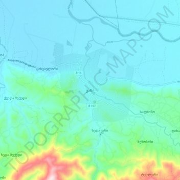
Name: Vani topographic map, elevation, terrain.

Location: Vani, Vani Municipality, Imereti, Georgia (42.04512 42.47198 42.12512 42.55198)

Average elevation: 114 m

Minimum elevation: 31 m

Maximum elevation: 555 m

Gear up for your next adventure:

Camping Tent - Weather-resistant tents suitable for 2 to 6 people
🛰️Satellite Messenger - Emergency communication for areas with no cell service
Family Camping Tent - Spacious tent suitable for family camping trips
🐕Hiking Dog Pack - Let your canine companion carry their own water and food
🥾Lightweight Hiking Boots - Boots for comfort and mobility on long hikes

As an Amazon Associate, this site earns from qualifying purchases at no extra cost to you.