
Make a donation
Gear up for your next adventure:
As an Amazon Associate, this site earns from qualifying purchases at no extra cost to you.
Sartichala topographic map
Click on the map to display elevation.
Make a donation
Gear up for your next adventure:
As an Amazon Associate, this site earns from qualifying purchases at no extra cost to you.
Sartichala
Sartichala is situated along the west bank of the Iori (river), atop the Iori Plateau, and lies at an elevation of 680 meters above sea level. The village is located approximately 34 kilometers east of Georgia's capital, Tbilisi and has the population of 6,009 (2014 census).
Make a donation
Gear up for your next adventure:
As an Amazon Associate, this site earns from qualifying purchases at no extra cost to you.
About this map
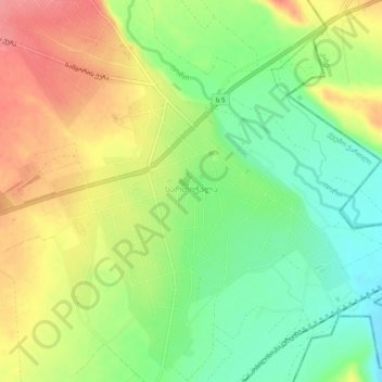
Name: Sartichala topographic map, elevation, terrain.
Location: Sartichala, Gardabani Municipality, Lower Kartli, Georgia (41.69627 45.14782 41.73115 45.19732)
Average elevation: 707 m
Minimum elevation: 669 m
Maximum elevation: 750 m
Make a donation
Gear up for your next adventure:
As an Amazon Associate, this site earns from qualifying purchases at no extra cost to you.