Geolocate

Bamberg topographic map

Click on the map to display elevation.

About this map

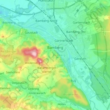
Name: Bamberg topographic map, elevation, terrain.

Location: Bamberg, Bavaria, Germany (49.84265 10.82650 49.92863 10.96070)

Average elevation: 267 m

Minimum elevation: 225 m

Maximum elevation: 386 m

Other topographic maps

Click on a map to view its topography, its elevation and its terrain.

Irsengund

Germany > Bavaria > Landkreis Lindau

Average elevation: 837 m

Inn

Germany > Bavaria > Landkreis Rosenheim > Wasserburg am Inn

Average elevation: 464 m

Allgäu

Germany > Bavaria

Average elevation: 1,087 m

Gögglbach

Germany > Bavaria > Landkreis Schwandorf > Schwandorf

Average elevation: 395 m

Stalling

Germany > Bavaria > Landkreis Traunstein > Palling

Average elevation: 543 m

Neuburg-Schrobenhausen

Germany > Bavaria

Average elevation: 483 m

Rubi

Germany > Bavaria > Landkreis Oberallgäu > Oberstdorf

Average elevation: 973 m

Horn

Germany > Bavaria > Ansbach (district) > Leutershausen

Average elevation: 471 m

Wind

Germany > Bavaria > Landkreis Bamberg

Average elevation: 284 m

Braun

Germany > Bavaria > Lappach > Braun

Average elevation: 558 m

Neukirchen

Germany > Bavaria > Eglharting > Neukirchen

Average elevation: 559 m

Ingolstadt

Germany > Bavaria > Ingolstadt > Ingolstadt

Average elevation: 409 m

Gänheim

Germany > Bavaria > Landkreis Main-Spessart > Arnstein > Gänheim

Average elevation: 265 m

Gear up for your next adventure:

🥾Durable Hiking Shoes - Long-lasting shoes for frequent hiking
🧦Hiking Socks - Moisture-wicking and comfortable socks for long hikes
🛶Kayak Accessories - Essential gear for safe and fun kayaking adventures
🏕️Camping Hammock - Integrated protection for sleeping between trees
🔪Outdoor Multitool - Versatile tool for repairs and food prep in the wild

As an Amazon Associate, this site earns from qualifying purchases at no extra cost to you.