Geolocate

Nördlingen topographic map

Click on the map to display elevation.

About this map

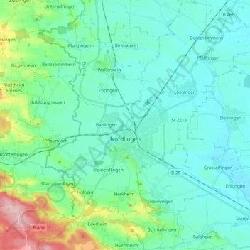
Name: Nördlingen topographic map, elevation, terrain.

Location: Nördlingen, Landkreis Donau-Ries, Bavaria, Germany (48.79459 10.42645 48.92256 10.59398)

Average elevation: 453 m

Minimum elevation: 408 m

Maximum elevation: 648 m

Gear up for your next adventure:

Tent Footprint - Protect tent floor and increase durability
🔦LED Flashlight - Powerful and long-lasting flashlight for camping and emergencies
🧥Packable Rain Jacket - Breathable waterproof layer for unpredictable weather
🦶Anti-Blister Balm - Prevents friction and hotspots during long ascents
Bushcraft Tarp - Versatile emergency shelter or gear protection

As an Amazon Associate, this site earns from qualifying purchases at no extra cost to you.