Geolocate

Bad Aibling topographic map

Click on the map to display elevation.

About this map

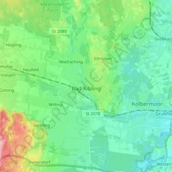
Name: Bad Aibling topographic map, elevation, terrain.

Location: Bad Aibling, Landkreis Rosenheim, Bavaria, 83043, Germany (47.81821 11.94576 47.91237 12.05439)

Average elevation: 488 m

Minimum elevation: 450 m

Maximum elevation: 605 m

Other topographic maps

Click on a map to view its topography, its elevation and its terrain.

Inn

Germany > Bavaria > Landkreis Rosenheim > Wasserburg am Inn

Average elevation: 464 m

Gear up for your next adventure:

🧢Sun Hat - Wide-brim hat for sun protection
🔭Compact Monocular - One-handed bird watching and trail spotting
🧤Rechargeable Heated Gloves - Extreme warmth for Canadian winter expeditions
🧤Thermal Hiking Gloves - Grip-enhanced gloves for cold-weather altitude trekking
🥾Trail Running Boots - Durable shoes designed for trail running

As an Amazon Associate, this site earns from qualifying purchases at no extra cost to you.