
Untersberg topographic map
Click on the map to display elevation.
Untersberg
Several trails lead to the top, though most people prefer the Untersbergbahn cable car. Constructed over a period of over two years, and opening in April 1961, the eight and a half minute journey lifts passengers from the lower terminus at the village of Sankt Leonhard at 456 m (1,496 ft) over 1,320 m (4,330 ft) to the top station on the Geiereck spur at an altitude of 1,776 m (5,827 ft), transporting them a horizontal distance of almost 2.5 km (1.6 mi) with a maximum height above the ground of 286 m (938 ft).
About this map
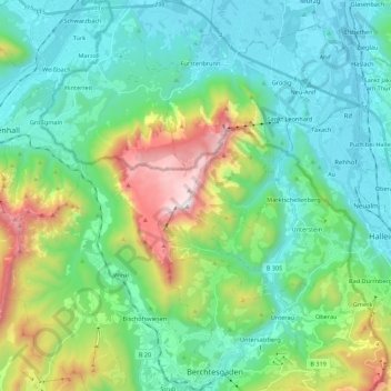
Name: Untersberg topographic map, elevation, terrain.
Location: Untersberg, Landkreis Berchtesgadener Land, Bavaria, Germany (47.62367 12.86522 47.77104 13.04785)
Average elevation: 797 m
Minimum elevation: 419 m
Maximum elevation: 1,952 m