
Chongqing topographic map
Interactive map
Click on the map to display elevation.
About this map
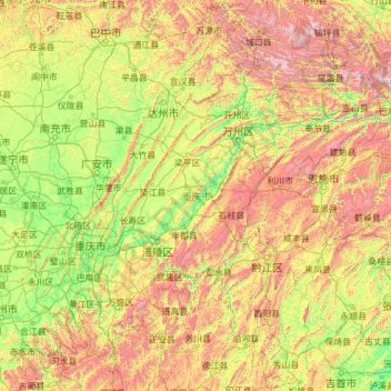
Name: Chongqing topographic map, elevation, terrain.
Location: Chongqing, China (28.16174 105.28683 32.20366 110.19444)
Average elevation: 754 m
Minimum elevation: 72 m
Maximum elevation: 3,007 m
The central urban area of Chongqing, or Chongqing proper, is a city of unique features. Built on mountains and partially surrounded by the Yangtze and Jialing rivers, it is known as a "mountain city" and a "city on rivers". The night scene of the city is very illuminated, with millions of lights and their reflection on the rivers. With its special topographical features, Chongqing has the unique scenery of mountains, rivers, forests, springs, waterfalls, gorges, and caves. Li Bai, a famous poet of the Tang dynasty, was inspired by the natural scenery and wrote this epigram.
Other topographic maps
Click on a map to view its topography, its elevation and its terrain.
Taiping District
Taiping District, Fuxin City, Liaoning, 123000, China
Average elevation: 235 m
Tazhong
China > Xinjiang > Qarqan County > Tazhong Town
Tazhong, Tazhong Town, Qarqan County, Bayingolin, Xinjiang, China
Average elevation: 1,116 m
Nam Bin Wai
China > Hong Kong > Yuen Long District > Tai Kiu Village
Nam Bin Wai, Tai Kiu Village, Yuen Long District, New Territories, Hong Kong, China
Average elevation: 16 m
CN/VN disputes in Paracel Islands
CN/VN disputes in Paracel Islands, Hainan Province, 573199, China
Average elevation: 0 m
Lion mountain
China > Zhejiang > Hangzhou City
Lion mountain, Hangzhou City, Zhejiang, 310024, China
Average elevation: 15 m
Keriya County
Keriya County, Hotan Prefecture, Xinjiang, 848400, China
Average elevation: 2,410 m
Yau Oi Chuen
China > Hong Kong > Sha Tin District > Tung Lo Wan
Yau Oi Chuen, Tung Lo Wan, Sha Tin District, New Territories, Hong Kong, China
Average elevation: 156 m
Wuhua District
Wuhua District, Kunming, Yunnan, China
Average elevation: 2,104 m
Daxingnanjiecun
China > Henan > Tangyin County
Daxingnanjiecun, Tangyin County, Anyang, Henan, China
Average elevation: 85 m
Ap Lei Chau
China > Hong Kong > Hong Kong Island
Ap Lei Chau, Southern District, Hong Kong Island, Hong Kong, China
Average elevation: 25 m
Yaha
China > Gansu > Zhugqu County > Wuping
Yaha, Wuping, Zhugqu County, Gannan, Gansu, 746300, China
Average elevation: 2,174 m
Huancui District
Huancui District, Weihai, Shandong, 264200, China
Average elevation: 41 m
Tai Mo Shan
China > Hong Kong > Tsuen Wan District
Tai Mo Shan, Tsuen Wan District, New Territories, Hong Kong, China
Average elevation: 600 m
Yiwu County
Yiwu County, Hami, Yiwu, Xinjiang, China
Average elevation: 1,215 m
Kaba
China > Xinjiang > Habahe County > 阿克齐镇
Kaba, 阿克齐镇, Habahe County, Altay Prefecture, Xinjiang, China
Average elevation: 557 m