Make a donation
Gear up for your next adventure:
As an Amazon Associate, this site earns from qualifying purchases at no extra cost to you.
Maqu County topographic map
Click on the map to display elevation.
Make a donation
Gear up for your next adventure:
As an Amazon Associate, this site earns from qualifying purchases at no extra cost to you.
Maqu County
Maqu County (simplified Chinese: 玛曲县; traditional Chinese: 瑪曲縣; pinyin: Mǎqū Xiàn; Tibetan: རྨ་ཆུ་རྫོང་།, Wylie: Rma chu rdzong, ZYPY: Maqu Zong) is a county of the Gannan Tibetan Autonomous Prefecture in the south of Gansu province of the People's Republic of China, bordering the provinces of Sichuan to the east and southeast, and Qinghai to the southwest, west and northwest. Its postal code is 747300, and in 1999 its population was 36,213 people. The area of Maqu County is 10,191 km2 with an average altitude of 3,700 meters. Maqu County receives high rainfall and is located at the northern edge of the Zoigê Marshes on the Yellow River where conditions are optimal for alpine meadow vegetation.
Make a donation
Gear up for your next adventure:
As an Amazon Associate, this site earns from qualifying purchases at no extra cost to you.
About this map
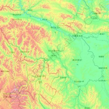
Name: Maqu County topographic map, elevation, terrain.
Average elevation: 3,812 m
Minimum elevation: 3,305 m
Maximum elevation: 5,295 m
Make a donation
Gear up for your next adventure:
As an Amazon Associate, this site earns from qualifying purchases at no extra cost to you.
Other topographic maps
Click on a map to view its topography, its elevation and its terrain.
Junma Sichang Qilian
China > Gansu > Shandan County > Shandan horse breeding area
Average elevation: 2,558 m
Mount Qilian
China > Gansu > Sunan Yugur Autonomous County > Qifeng Tibetan Ethnic Township
Average elevation: 5,071 m
Make a donation
Gear up for your next adventure:
As an Amazon Associate, this site earns from qualifying purchases at no extra cost to you.
Make a donation
Gear up for your next adventure:
As an Amazon Associate, this site earns from qualifying purchases at no extra cost to you.
Make a donation
Gear up for your next adventure:
As an Amazon Associate, this site earns from qualifying purchases at no extra cost to you.
Make a donation
Gear up for your next adventure:
As an Amazon Associate, this site earns from qualifying purchases at no extra cost to you.
Make a donation
Gear up for your next adventure:
As an Amazon Associate, this site earns from qualifying purchases at no extra cost to you.
Make a donation
Gear up for your next adventure:
As an Amazon Associate, this site earns from qualifying purchases at no extra cost to you.
Gannan
China > Gansu > Hezuo City > Tongqin
Gannan, as illustrated by this chart for Xiahe, has an alpine subarctic climate (Köppen Dwc) that grades into an alpine climate (ETH) at the highest elevations. The climate is characterised by mild, rainy summers and frigid, but dry and sunny, winters.
Average elevation: 3,075 m
Zhangye Danxia National Geological Park
China > Gansu > Linze County > Nantai
Average elevation: 1,759 m
Make a donation
Gear up for your next adventure:
As an Amazon Associate, this site earns from qualifying purchases at no extra cost to you.
Make a donation
Gear up for your next adventure:
As an Amazon Associate, this site earns from qualifying purchases at no extra cost to you.
Baiyin
Baiyin is part loess plateau, part desert. Elevation ranges from 1,275 to 3,321 meters (4,183 to 10,896 feet) above sea-level. The climate is very arid with only 110–352 mm (4.3–13.9 in) of annual precipitation. Annual evaporation is 2,101 mm (82.7 in) resulting in a net loss of approximately 1,800 mm (71…
Average elevation: 1,836 m
Make a donation
Gear up for your next adventure:
As an Amazon Associate, this site earns from qualifying purchases at no extra cost to you.
