
Thank you for supporting this site ❤️
Make a donation
Make a donation
Gear up for your next adventure:
As an Amazon Associate, this site earns from qualifying purchases at no extra cost to you.
Yueyaquan topographic map
Click on the map to display elevation.
Thank you for supporting this site ❤️
Make a donation
Make a donation
Gear up for your next adventure:
As an Amazon Associate, this site earns from qualifying purchases at no extra cost to you.
About this map
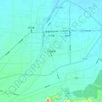
Name: Yueyaquan topographic map, elevation, terrain.
Location: Yueyaquan, Dunhuang City, Jiuquan, Gansu, 736200, China (40.08566 94.62326 40.16566 94.70326)
Average elevation: 1,148 m
Minimum elevation: 1,127 m
Maximum elevation: 1,302 m
Thank you for supporting this site ❤️
Make a donation
Make a donation
Gear up for your next adventure:
As an Amazon Associate, this site earns from qualifying purchases at no extra cost to you.
Other topographic maps
Click on a map to view its topography, its elevation and its terrain.