Geolocate

Bola topographic map

Click on the map to display elevation.

About this map

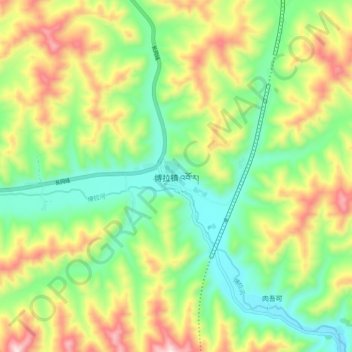
Name: Bola topographic map, elevation, terrain.

Location: Bola, Xiahe County, Gannan, Gansu, China (34.78545 102.80279 34.86545 102.88279)

Average elevation: 3,102 m

Minimum elevation: 2,878 m

Maximum elevation: 3,453 m

Gear up for your next adventure:

🔭Compact Monocular - One-handed bird watching and trail spotting
🔥Emergency Fire Starter - Reliable ignition source for all weather conditions
👟Leg Gaiters - Keep debris, mud, and snow out of your boots
🧥Softshell Jacket - Windproof and breathable jacket for hiking
Camping Coffee Maker - Brew fresh coffee anywhere on the topographic map

As an Amazon Associate, this site earns from qualifying purchases at no extra cost to you.