
Wolfsburg topographic map
Click on the map to display elevation.
About this map
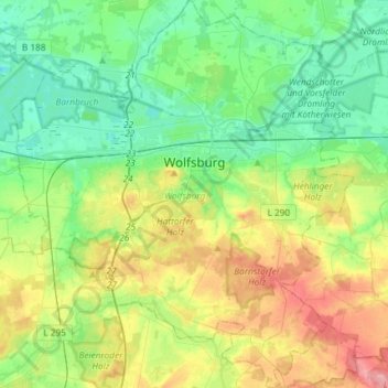
Name: Wolfsburg topographic map, elevation, terrain.
Location: Wolfsburg, Lower Saxony, Germany (52.31593 10.64711 52.49509 10.90684)
Average elevation: 84 m
Minimum elevation: 47 m
Maximum elevation: 161 m
Other topographic maps
Click on a map to view its topography, its elevation and its terrain.
Kamschlacken
Germany > Lower Saxony > Landkreis Göttingen > Osterode am Harz > Riefensbeek-Kamschlacken
Average elevation: 513 m
Klein Schweinebrück
Germany > Lower Saxony > Landkreis Friesland > Zetel > Schweinebrück
Average elevation: 9 m
Hagelshoek
Germany > Lower Saxony > Landkreis Grafschaft Bentheim > Bad Bentheim > Gildehaus
Average elevation: 48 m
Zoll
Germany > Lower Saxony > Landkreis Göttingen > Bad Lauterberg im Harz > Barbis
Average elevation: 315 m
Pötzen
Germany > Lower Saxony > Landkreis Hameln-Pyrmont > Hessisch Oldendorf
Average elevation: 200 m
Klein Eissel
Germany > Lower Saxony > Landkreis Verden > Verden (Aller) > Eissel bei Verden
Average elevation: 11 m
Lüneburg Heath
Germany > Lower Saxony > Heidekreis > Soltau > Hötzingen > Emhof
Average elevation: 85 m
Schwagstorf
Germany > Lower Saxony > Landkreis Osnabrück > Fürstenau > Schwagstorf
Average elevation: 84 m