Euphrates topographic map
Click on the map to display elevation.
About this map
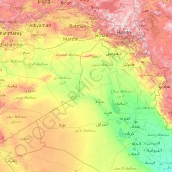
Name: Euphrates topographic map, elevation, terrain.
Location: Euphrates, Syria (30.91048 37.83444 39.72876 47.44235)
Average elevation: 793 m
Minimum elevation: -415 m
Maximum elevation: 4,232 m
Other topographic maps
Click on a map to view its topography, its elevation and its terrain.
Jisr ash-Shugur
Jisr ash-Shughūr (Arabic: جِسْرُ ٱلشُّغُورِ, romanized: jisr aš-šuġūr, pronounced [dʒɪsr aʃ.ʃuˈɣuːr], also rendered as Jisser ash-Shughour and other spellings), known in antiquity as Seleucobelus (Greek: Σελευκόβηλος, romanized: Seleukóbēlos), is a city in the Idlib…
Average elevation: 272 m
Jisr ash-Shugur
Jisr ash-Shughūr (Arabic: جِسْرُ ٱلشُّغُورِ, romanized: jisr aš-šuġūr, pronounced [dʒɪsr aʃ.ʃuˈɣuːr], also rendered as Jisser ash-Shughour and other spellings), known in antiquity as Seleucobelus (Greek: Σελευκόβηλος, romanized: Seleukóbēlos), is a city in the Idlib…
Average elevation: 272 m






Al-Bab
Al-Bab (Arabic: الْبَاب / ALA-LC: al-Bāb, Kurdish: Derî) is a Syrian city, administratively belonging to the Aleppo Governorate. Al-Bab is located 40 kilometres (25 mi) northeast of Aleppo, 30 kilometres (19 mi) south of the Turkish border, and has an area of 30 square kilometres (12 square miles).…
Average elevation: 471 m



Khan Shaykhoun
Khan Shaykhun is located at an altitude of 350 meters on the main highway between Aleppo and Damascus. The local economy is primarily agricultural, focusing on the growing of cotton and cereals. The town was formerly known for producing embroidery. Nearby localities include Hbit to the west, Kafr Zita to…
Average elevation: 385 m



Idlib
Idlib (Arabic: إِدْلِب, romanized: ʾIdlib, pronounced [ʔid.lib]; also spelt Idleb or Edlib) is a city in northwestern Syria, and is the capital of the Idlib Governorate. It has an elevation of nearly 500 meters (1,600 ft) above sea level, and is 59 kilometers (37 mi) southwest of Aleppo. The city was…
Average elevation: 394 m


Idlib
Idlib (Arabic: إِدْلِب, romanized: ʾIdlib, pronounced [ʔid.lib]; also spelt Idleb or Edlib) is a city in northwestern Syria, and is the capital of the Idlib Governorate. It has an elevation of nearly 500 meters (1,600 ft) above sea level, and is 59 kilometers (37 mi) southwest of Aleppo. It is located…
Average elevation: 394 m

An-Nabk
Syria > Rif Dimashq Governorate
An-Nabek or Al-Nabek (Arabic: ٱلنَّبْك, romanized: an-Nabk) is a Syrian city administratively belonging to Rif Dimashq and the capital of the Qalamoun. Located 81 kilometers (50 mi) north of Damascus and south of Homs. It has an altitude of 1255 meters. According to the Syria Central Bureau of…
Average elevation: 1,304 m


Saraqib
It has an elevation of 370 meters above sea level. The ancient site of Ebla is situated five kilometers south of the city. Nearby localities include Mardikh and Maar Dibsah to the south, Tronba and al-Nayrab to the west, Sarmin to the northwest, Taftanaz to the north, Talhiyah to the northeast, Tell Touqan to…
Average elevation: 358 m



Barada River
Syria > Damascus Governorate > Damascus Subdistrict > Al-Qanawat Municipality
Average elevation: 703 m
Afrin
In August 2015, the University of Afrin started teaching, with initial programs in literature, engineering and economics, including institutes for medicine, topographic engineering, music and theater, business administration and the Kurdish language. In January 2018, the university closed due to Operation…
Average elevation: 309 m


An-Nabk
Syria > Rif Dimashq Governorate
An-Nabek or Al-Nabek (Arabic: النبك, romanized: an-Nabk) is a Syrian city administratively belonging to Rif Dimashq and the capital of the Qalamoun. Located 81 kilometers (50 mi) north of Damascus and south of Homs. It has an altitude of 1255 meters. According to the Syria Central Bureau of Statistics…
Average elevation: 1,304 m
Az-Zabadani
Syria > Rif Dimashq Governorate
Al-Zabadani or Az-Zabadani (Arabic: الزبداني, romanized: az-Zabadānī) is a city and popular hill station in southwestern Syria in the Rif Dimashq Governorate, close to the border with Lebanon. It is located in the center of a green valley surrounded by high mountains at an elevation of around 1,100 m.
Average elevation: 1,429 m

Idlib
Idlib (Arabic: إِدْلِب, romanized: ʾIdlib, pronounced [ʔid.lib]; also spelt Idleb or Edlib) is a city in northwestern Syria, and is the capital of the Idlib Governorate. It has an elevation of nearly 500 meters (1,600 ft) above sea level, and is 59 kilometers (37 mi) southwest of Aleppo. It is located…
Average elevation: 394 m

Safita
Syria gained its independence in 1946. In 1960, Safita's population consisted of 4,300 Christians and 1,900 Alawites. With Tartus's elevation as the capital of a new governorate, the Tartus Governorate, in 1967, Safita's administrative subordination to Tartus was reinforced. The increased civic importance of…
Average elevation: 245 m



At-Tall
Syria > Rif Dimashq Governorate
Al-Tall (Arabic: التل, romanized: at-Tall, also spelled al-Tell) is a city in southern Syria, administratively part of the Rif Dimashq Governorate and capital of the al-Tall District. Situated in the middle of the Anti-Lebanon Mountains, having an elevation of roughly 1,000 meters above sea level. Nearby…
Average elevation: 1,037 m

Azaz
During the Crusader era, Azaz, which was referred to in Crusader sources as "Hazart", became of particular strategic significance due to its topography and location, overlooking the surrounding region. In the hands of the Muslims, Azaz stymied communications between the Crusader states of Edessa and Antioch,…
Average elevation: 559 m



Harasta
Syria > Rif Dimashq Governorate
Harasta (Arabic: حرستا, romanized: Ḥarastā, Syriac: ܚܪܣܬܐ, romanized: Ḥarastā), also known as Harasta al-Basal or Hirista, is a town and northeastern suburb of Damascus, Rif Dimashq, Syria. Harasta has an altitude of 702 meters. It has a population of 34,184 as of 2007, making it the 43rd…
Average elevation: 880 m