Geolocate

Az-Zabadani topographic map

Click on the map to display elevation.

Az-Zabadani

Al-Zabadani or Az-Zabadani (Arabic: الزبداني, romanized: az-Zabadānī) is a city and popular hill station in southwestern Syria in the Rif Dimashq Governorate, close to the border with Lebanon. It is located in the center of a green valley surrounded by high mountains at an elevation of around 1,100 m.

Wikipedia (CC-BY-SA 3.0)

About this map

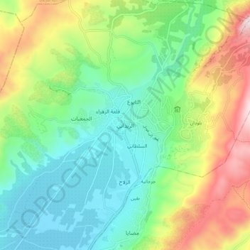
Name: Az-Zabadani topographic map, elevation, terrain.

Location: Az-Zabadani, Az-Zabadani Subdistrict, Az-Zabadani District, Rif Dimashq Governorate, Syria (33.68445 36.06019 33.76445 36.14019)

Average elevation: 1,429 m

Minimum elevation: 1,099 m

Maximum elevation: 2,100 m

Other topographic maps

Click on a map to view its topography, its elevation and its terrain.

Al Nabek dam

Syria > Rif Dimashq Governorate

Average elevation: 1,247 m

Duma District

Syria > Rif Dimashq Governorate

Average elevation: 801 m

Zarzar Lake

Syria > Rif Dimashq Governorate

Average elevation: 1,201 m

Douma District

Syria > Rif Dimashq Governorate

Average elevation: 801 m

Qatana District

Syria > Rif Dimashq Governorate

Average elevation: 1,122 m

Gear up for your next adventure:

🥾Hiking Gaiters - Protect legs and shoes from mud, snow, and debris
🧳Compression Sacks - Maximize space in your backpack by shrinking gear
🧥Fleece Jacket - Warm and lightweight jacket for layering
Family Camping Tent - Spacious tent suitable for family camping trips
Camping Groundsheet - Protect your tent from moisture and dirt

As an Amazon Associate, this site earns from qualifying purchases at no extra cost to you.