
Palm Beach County topographic map
Interactive map
Click on the map to display elevation.
About this map
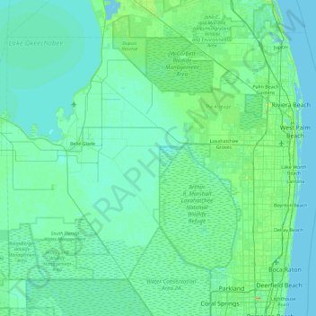
Name: Palm Beach County topographic map, elevation, terrain.
Location: Palm Beach County, Florida, United States (26.32068 -80.88623 26.97092 -79.97431)
Average elevation: 5 m
Minimum elevation: -3 m
Maximum elevation: 42 m
Other topographic maps
Click on a map to view its topography, its elevation and its terrain.
Parrish
United States > Florida > Manatee County
Parrish features a predominantly flat terrain with an average elevation of approximately 36 feet above sea level. The area's landscape is characterized by gently rolling hills and low-lying regions, making it typical of the Central Florida topography. Surrounding Parrish are numerous wetlands and drainage…
Average elevation: 12 m
Nokomis
United States > Florida > Sarasota County
Nokomis features a predominantly flat and low-lying terrain characteristic of the coastal region. The elevation in Nokomis rarely exceeds 15 feet above sea level, contributing to its vulnerability to tidal influences and storm surges. The area is interspersed with wetlands and mangroves, particularly near the…
Average elevation: 5 m
Palm Harbor
United States > Florida > Pinellas County
Palm Harbor is characterized by its unique topography, which features a relatively rare hilly landscape for the region. Unlike much of the surrounding areas in Pinellas County, which are predominantly flat, Palm Harbor includes elevations that can reach up to about 75 feet above sea level. This elevation gives…
Average elevation: 9 m
Arbors at Freedom Plaza
United States > Florida > Hillsborough County > Sun City Center
Average elevation: 15 m
Port Charlotte
United States > Florida > Charlotte County
Port Charlotte is characterized by a predominantly flat and low-lying terrain, typical of Florida’s coastal landscape. The area features a network of waterways, including the Peace River and Charlotte Harbor, which provide ample opportunities for recreational activities like boating and fishing. Elevations…
Average elevation: 4 m
Anna Maria island
United States > Florida > Manatee County
Anna Maria Island features a flat, sandy topography typical of a barrier island on the Gulf Coast. With an average elevation of around 15 feet above sea level, the terrain includes broad beaches, low dunes, and narrow stretches of sandy soil, making it highly vulnerable to storm surges and tidal flooding. The…
Average elevation: 2 m
South Gulf Cove Park
United States > Florida > Charlotte County > Port Charlotte
Average elevation: 3 m
Navarre
United States > Florida > Santa Rosa County
Navarre is located at 30°24′04″N 86°51′47″W / 30.401°N 86.863°W / 30.401; -86.863Coordinates: 30°24′04″N 86°51′47″W / 30.401°N 86.863°W / 30.401; -86.863. It is located within a portion of the Florida Panhandle observing the Central Time Zone. Elevation is at an average of 10 feet (3.0 m).
Average elevation: 4 m
Florida Keys
United States > Florida > Monroe County
Tropical cyclones present special dangers and challenges to the entire Keys. Because no area of the islands is more than 20 feet (6.1 m) above sea level (and many are only a few feet elevation), and water surrounds the islands, nearly every neighborhood is subject to flooding as well as hurricane winds. In…
Average elevation: 0 m
Ponte Vedra Beach
United States > Florida > Saint Johns County > Ponte Vedra Beach
Ponte Vedra Beach is characterized by its gently rolling terrain that is primarily flat and lies only about 15 feet above sea level. The landscape is predominantly shaped by coastal dunes and the proximity to the Atlantic Ocean, resulting in sandy beaches interspersed with vegetation typical of barrier island…
Average elevation: 3 m
Union Park
United States > Florida > Orange County
According to the United States Census Bureau, the CDP has a total area of 7.8 km2 (3.0 mi2), of which 7.7 km2 (3.0 mi2) is land and 0.1 km2 (0.04 mi2) (0.99%) is water. The elevation is 82 feet (25 m) above sea level.
Average elevation: 16 m
Wesley Chapel
United States > Florida > Pasco County
According to the United States Census Bureau, the CDP has a total area of 6.1 square miles (16 km2), of which 6.1 square miles (16 km2) is land and 0.04 square miles (0.10 km2) (0.49%) is water. The elevation is about 100 feet (30 m), combined with an inland location, creates more temperature variation in the…
Average elevation: 19 m
Jensen Beach
United States > Florida > Martin County
The Skyline Drive area includes some of the highest points in the community, reaching an elevation of 70 feet (21 m) at one point.
Average elevation: 5 m
Fred O. Drake Park at Lake Ella
United States > Florida > Leon County > Tallahassee
Average elevation: 56 m
Jacksonville
United States > Florida > Duval County > Jacksonville
Just south of Jacksonville and north of Saint Augustine is the boundary of where the Floridian Peninsula ends and Continental North America begins; Jacksonville is north of that line. While still in the North American Coastal plain, the topography begins to take on slight Piedmont characteristics. Like the…
Average elevation: 9 m
Lake Ella
United States > Florida > Leon County > Tallahassee
In 1986, Lake Ella underwent extensive rehabilitation including sediment removal, reshaping of the shoreline, reducing the number of stormwater inflow pipes, and installation of an automatic alum treatment system. Lake Ella receives stormwater runoff from an urban watershed that is approximately 157 acres…
Average elevation: 56 m
Englewood
United States > Florida > Sarasota County
Englewood features predominantly flat and low-lying terrain typical of the region's coastal landscape. The average elevation here is approximately 15 feet above sea level, which makes the area particularly susceptible to tidal influences and storm surges. The terrain is interspersed with wetlands and…
Average elevation: 3 m
Southfort
United States > Florida > DeSoto County
It is located at 27°04′05″N 81°57′50″W / 27.068°N 81.964°W / 27.068; -81.964, its elevation 26 feet (7.9 m).
Average elevation: 9 m
Myakka City
United States > Florida > Manatee County
Myakka City (also Myakka) is an unincorporated community in southeastern Manatee County, Florida, United States. It lies along State Road 70 near the city of Bradenton, the county seat of Manatee County. Its elevation is 43 feet (13 m), and it is located at 27°20′59″N 82°9′41″W / 27.34972°N…
Average elevation: 14 m
Samsula-Spruce Creek
United States > Florida > Volusia County > New Smyrna Beach > South Village
Average elevation: 8 m
Lake Jackson
United States > Florida > Leon County
The lake is located in the Red Hills Region, and has fluctuated from periods of being dry to a maximum elevation of 96 feet (29 m) above sea level. The lake is approximately 7.5 miles (12 km) long and its area is 6.2 square miles (16 km2). There is no outflow from streams or runoff.
Average elevation: 45 m
Cape Canaveral
United States > Florida > Brevard County
The hurricane of August 1885, pushed a "wall of water" over the barrier island (elevation, 3.1 m (10 ft)) devastating Cape Canaveral and adjacent areas. The ocean waves flooded the homesteaders and discouraged further settlement in the area. The beach near the lighthouse was severely eroded prompting its…
Average elevation: 1 m
Hillsborough Heights East
United States > Florida > Hillsborough County > Tampa
Average elevation: 18 m