Geolocate

Nokomis topographic map

Click on the map to display elevation.

About this map

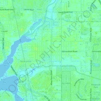
Name: Nokomis topographic map, elevation, terrain.

Location: Nokomis, Sarasota County, Florida, United States (27.10853 -82.45906 27.13793 -82.41717)

Average elevation: 5 m

Minimum elevation: -2 m

Maximum elevation: 10 m

Other topographic maps

Click on a map to view its topography, its elevation and its terrain.

Woodmere

United States > Florida > Sarasota County > Venice

Average elevation: 5 m

Pinecraft

United States > Florida > Sarasota County

Average elevation: 10 m

Plantation

United States > Florida > Sarasota County

Average elevation: 5 m

Gear up for your next adventure:

👖Convertible Hiking Pants - Zip-off legs to adapt to changing weather conditions
🥽Outdoor Goggles - Protective eyewear for outdoor activities
Camping Groundsheet - Protect your tent from moisture and dirt
🥾Lightweight Hiking Boots - Boots for comfort and mobility on long hikes
🧣Merino Neck Gaiter - Protects against wind, sun, and cold at high altitudes

As an Amazon Associate, this site earns from qualifying purchases at no extra cost to you.