
Make a donation
Gear up for your next adventure:
As an Amazon Associate, this site earns from qualifying purchases at no extra cost to you.
Southfort topographic map
Click on the map to display elevation.
Make a donation
Gear up for your next adventure:
As an Amazon Associate, this site earns from qualifying purchases at no extra cost to you.
Southfort
It is located at 27°04′05″N 81°57′50″W / 27.068°N 81.964°W / 27.068; -81.964, its elevation 26 feet (7.9 m).
Make a donation
Gear up for your next adventure:
As an Amazon Associate, this site earns from qualifying purchases at no extra cost to you.
About this map
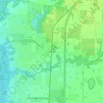
Name: Southfort topographic map, elevation, terrain.
Location: Southfort, DeSoto County, Florida, 34269, United States (27.04811 -81.98398 27.08811 -81.94398)
Average elevation: 9 m
Minimum elevation: 1 m
Maximum elevation: 16 m
Make a donation
Gear up for your next adventure:
As an Amazon Associate, this site earns from qualifying purchases at no extra cost to you.
Other topographic maps
Click on a map to view its topography, its elevation and its terrain.
Arcadia
United States > Florida > DeSoto County
Arcadia is located slightly northwest of the center of DeSoto County at 27°13'N 81°52'W (27.2176, –81.8599). The Peace River flows past the west side of the city on its way southwest to tidewater at Punta Gorda. Most of Arcadia is more than 40 feet (12 m) above sea level and portions of Arcadia near the…
Average elevation: 17 m