
Ferry Pass topographic map
Click on the map to display elevation.
About this map
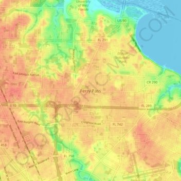
Name: Ferry Pass topographic map, elevation, terrain.
Location: Ferry Pass, Escambia County, Florida, 32514, United States (30.47020 -87.25247 30.55020 -87.17247)
Average elevation: 29 m
Minimum elevation: -4 m
Maximum elevation: 47 m
Other topographic maps
Click on a map to view its topography, its elevation and its terrain.
Pensacola
United States > Florida > Escambia County
Pensacola features a diverse topography characterized primarily by its proximity to the Gulf of Mexico and the sheltered Pensacola Bay. The terrain gently slopes upward from the waterfront, resulting in a gradual elevation that provides natural protection against storm surges, making it somewhat less…
Average elevation: 21 m
Pensacola
United States > Florida > Escambia County
The land is sloped up northward from Pensacola Bay, with most of the city at an elevation above that which a potential hurricane storm surge could affect.
Average elevation: 21 m
Pensacola
United States > Florida > Escambia County
The land is sloped up northward from Pensacola Bay, with most of the city at an elevation above that which a potential hurricane storm surge could affect.
Average elevation: 21 m
Pensacola
United States > Florida > Escambia County
The land is sloped up northward from Pensacola Bay, with most of the city at an elevation above that at which a potential hurricane storm surge could affect.
Average elevation: 21 m
Pensacola
United States > Florida > Escambia County
The land is sloped up northward from Pensacola Bay, with most of the city at an elevation above that at which a potential hurricane storm surge could affect.
Average elevation: 21 m
Pensacola
United States > Florida > Escambia County
The land is sloped up northward from Pensacola Bay, with most of the city at an elevation above that at which a potential hurricane storm surge could affect.
Average elevation: 21 m