
Make a donation
Gear up for your next adventure:
As an Amazon Associate, this site earns from qualifying purchases at no extra cost to you.
Lake Ella topographic map
Click on the map to display elevation.
Make a donation
Gear up for your next adventure:
As an Amazon Associate, this site earns from qualifying purchases at no extra cost to you.
Lake Ella
In 1986, Lake Ella underwent extensive rehabilitation including sediment removal, reshaping of the shoreline, reducing the number of stormwater inflow pipes, and installation of an automatic alum treatment system. Lake Ella receives stormwater runoff from an urban watershed that is approximately 157 acres (635,000 m2) in area. During a typical year the lake treats somewhere around 250 million gallons (946,352 cu. m) of stormwater runoff. During normal water elevations the lake stores approximately 27 million gallons (102,206 cu. m) of water. During excessive rain events the lake can store an additional 9 million gallons (34,068 cu. m). Pollutant treatment is obtained through an automated system that doses alum at six locations based on the volume of stormwater entering the lake. Alum, which is a substance used by some communities to treat drinking water, mixes with incoming stormwater and causes pollutants to settle to the lake bottom.
Make a donation
Gear up for your next adventure:
As an Amazon Associate, this site earns from qualifying purchases at no extra cost to you.
About this map
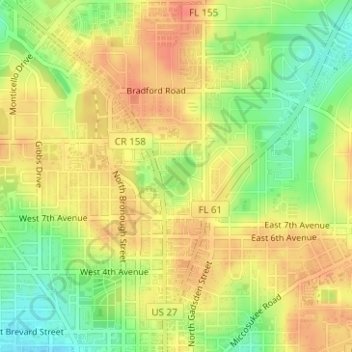
Name: Lake Ella topographic map, elevation, terrain.
Location: Lake Ella, Tallahassee, Leon County, Florida, United States (30.45958 -84.28080 30.46237 -84.27794)
Average elevation: 56 m
Minimum elevation: 27 m
Maximum elevation: 75 m
Make a donation
Gear up for your next adventure:
As an Amazon Associate, this site earns from qualifying purchases at no extra cost to you.
Other topographic maps
Click on a map to view its topography, its elevation and its terrain.