
Valdemorillo topographic map
Click on the map to display elevation.
Valdemorillo
El término se asienta sobre suelo granítico, aunque también aparecen masas arcillosas de consideración, fruto de la sedimentación del río Aulencia, que atraviesa el municipio. Su altitud media es de 815 m sobre el nivel del mar.
About this map
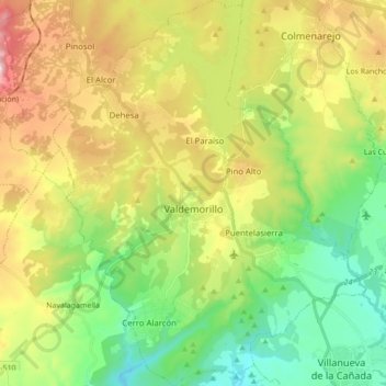
Name: Valdemorillo topographic map, elevation, terrain.
Location: Valdemorillo, Comunidad de Madrid, España (40.44123 -4.13167 40.57226 -3.99190)
Average elevation: 799 m
Minimum elevation: 568 m
Maximum elevation: 1,171 m
Other topographic maps
Click on a map to view its topography, its elevation and its terrain.
Río del Riato
España > Comunidad de Madrid > Sierra Norte > Berzosa del Lozoya
Average elevation: 1,254 m
Madrid
España > Comunidad de Madrid > Madrid
El casco antiguo, con origen en la medina musulmana, surge de un emplazamiento estratégico (el control de un vado del Manzanares) que determinará una serie de limitaciones topográficas: la disposición del caserío original en las zonas elevadas sobre el río y el barranco de la calle de Segovia, donde se…
Average elevation: 650 m
Gargantilla del Lozoya
España > Comunidad de Madrid > Gargantilla del Lozoya y Pinilla de Buitrago
Average elevation: 1,170 m
Monte de El Pardo
España > Comunidad de Madrid > Área metropolitana de Madrid y Corredor del Henares > Madrid
Más allá de la acción erosiva, la orografía del paraje es poco accidentada. El Monte de El Pardo está formado por lomas pequeñas y onduladas, que bajan en suave pendiente hacia el valle del Manzanares, que lo atraviesa de norte a sur. Su altitud media es de 681 metros, con un mínimo de 600 metros y un…
Average elevation: 689 m
Sierra de Guadarrama
Para dividir la sierra en zonas se pueden tener en cuenta diferentes criterios. Si se usa el de la ubicación, se puede dividir en la zona noreste y la suroeste. Estas dos áreas están separadas por la zona comprendida entre los puertos de Navacerrada y Cotos, separados entre sí por 5,6 km. Ambos puertos…
Average elevation: 1,234 m
Alcobendas
Alcobendas es un municipio de España perteneciente a la Comunidad de Madrid. Se encuentra a 15 km al norte de la capital y a 669 m de altitud sobre el nivel del mar. Limita con los municipios de San Sebastián de los Reyes, al norte; Madrid, al oeste y al sur; y Paracuellos de Jarama, al este. En 2022 contaba…
Average elevation: 680 m
Zarzalejo (estación)
La localidad está situada a una altitud de 1104 m sobre el nivel del mar. Este se encuentra a los pies de dos montañas graníticas: la Machota Alta (1464 m), popularmente llamada el Pico del Fraile, y la Machota Baja (1404 m), que forman parte de las estribaciones meridionales de la sierra de…
Average elevation: 1,020 m
Acebo del puerto de Canencia. Árbol singular de la Comunidad de Madrid Nº 76
España > Comunidad de Madrid > Canencia
Average elevation: 1,484 m
Valle de San Juan - Los Vallejos
España > Comunidad de Madrid > Colmenar de Oreja
Average elevation: 609 m
Embalse de San Juan
España > Comunidad de Madrid > San Martín de Valdeiglesias
Average elevation: 682 m
Presa del Embalse de Navacerrada
España > Comunidad de Madrid > Navacerrada
Average elevation: 1,513 m
Río Guadarrama
España > Comunidad de Madrid > Las Rozas de Madrid
El río Guadarrama es un afluente del Tajo que nace en la Comunidad de Madrid (España), a la que atraviesa en sus cursos alto y medio. Surca en su curso bajo la provincia de Toledo, donde desemboca después de recorrer 131,8 kilómetros. Tiene su origen en el valle de la Fuenfría, a unos 1900 m de altitud,…
Average elevation: 648 m
Los Helechos
España > Comunidad de Madrid > Cercedilla > Urbanización Valle de Fuenfría
Average elevation: 1,364 m
Puerto de Navacerrada
España > Comunidad de Madrid > Cuenca del Guadarrama > Los Baldíos > Puerto de Navacerrada
Average elevation: 1,812 m
Abantos
España > Comunidad de Madrid > San Lorenzo de El Escorial
Es uno de los más importantes de la sierra de Guadarrama (perteneciente al sistema Central). Tiene una altitud de 1753 metros. La vertiente norte de la montaña está en el valle de Cuelgamuros, mientras que la parte oeste de la cima pertenece a la provincia de Ávila (Castilla y León).
Average elevation: 1,491 m
Corral de Peña Jardinera
España > Comunidad de Madrid > Becerril de la Sierra
Average elevation: 1,304 m
Cerro de la Porrilla
España > Comunidad de Madrid > Horcajuelo de la Sierra
Average elevation: 1,330 m
La Pedriza
España > Comunidad de Madrid > Sierra Norte > Garganta de los Montes
Average elevation: 1,575 m
Alcorcón
España > Comunidad de Madrid > Alcorcón
Durante el reinado de Felipe II (1556-1598) se publicaron las Relaciones Topográficas de Felipe II, una enciclopedia en la que se recogieron los datos topográficos e históricos de los pueblos de Castilla. En el capítulo II figura.
Average elevation: 646 m
Fuenlabrada
España > Comunidad de Madrid > Área metropolitana de Madrid y Corredor del Henares > Fuenlabrada
Las Relaciones de Francisco Antonio de Lorenzana (1784) recogen una descripción sobre el nombre del pueblo, que ha sido asumida por el Ayuntamiento de Fuenlabrada como oficial. El siguiente texto se ha extraído de la edición actualizada de las Relaciones topográficas de Felipe II, coordinada por Alfredo…
Average elevation: 630 m
La Cañada
España > Comunidad de Madrid > Sierra Norte > Villavieja del Lozoya > La Cañada
Average elevation: 1,045 m
La Maliciosa Baja
España > Comunidad de Madrid > Cuenca del Guadarrama > El Boalo
La Maliciosa es una de las montañas más importantes y altas de la sierra de Guadarrama, una formación montañosa perteneciente al Sistema Central. Tiene una altitud de 2227 metros sobre el nivel del mar y está situada en el noroeste de la Comunidad de Madrid, en España, alzándose entre La Pedriza, que…
Average elevation: 1,716 m