
Los Hueros topographic map
Interactive map
Click on the map to display elevation.
About this map
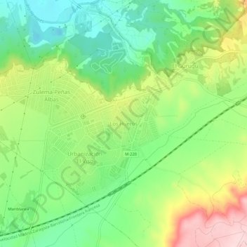
Name: Los Hueros topographic map, elevation, terrain.
Location: Los Hueros, Villalbilla, Comunidad de Madrid, 28810, España (40.42506 -3.37500 40.46506 -3.33500)
Average elevation: 666 m
Minimum elevation: 569 m
Maximum elevation: 818 m
Other topographic maps
Click on a map to view its topography, its elevation and its terrain.
Llano de la Perdiz
España > Comunidad de Madrid > Villalbilla
Llano de la Perdiz, Villalbilla, Cuenca del Henares, Comunidad de Madrid, 28810, España
Average elevation: 701 m