Geolocate

Regajo topographic map

Click on the map to display elevation.

About this map

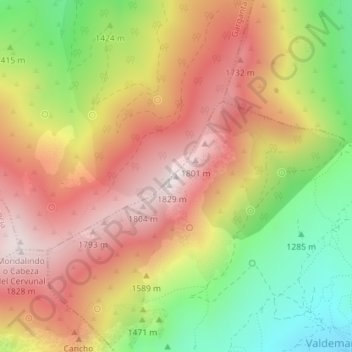
Name: Regajo topographic map, elevation, terrain.

Location: Regajo, Valdemanco, Comunidad de Madrid, 28743, España (40.88636 -3.68010 40.88646 -3.68000)

Average elevation: 1,513 m

Minimum elevation: 1,139 m

Maximum elevation: 1,825 m

Gear up for your next adventure:

💡LED Camping Lantern - Illuminate your campsite with long-lasting lanterns
🗺️Topographic Maps - Detailed maps to explore trails, mountains, and wilderness areas
🪜Heavy Duty Carabiners - Multi-use clips for securing gear to your backpack
🛶Waterproof Dry Bags - Keep electronics and clothes dry during river crossings
🔭Outdoor Binoculars - Lightweight binoculars for birdwatching and hiking

As an Amazon Associate, this site earns from qualifying purchases at no extra cost to you.