Geolocate

Ballard County topographic map

Click on the map to display elevation.

About this map
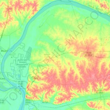
Name: Ballard County topographic map, elevation, terrain.

Location: Ballard County, Kentucky, United States (36.91546 -89.18251 37.23010 -88.81582)

Average elevation: 113 m

Minimum elevation: 87 m

Maximum elevation: 152 m

Other topographic maps

Click on a map to view its topography, its elevation and its terrain.
Highway

United States > Kentucky > Clinton County

Average elevation: 287 m

Mayfield

United States > Kentucky > Graves County > Mayfield > Mayfield

Average elevation: 148 m

Finney

United States > Kentucky > Barren County

Average elevation: 187 m

Freeburn

United States > Kentucky > Pike County

Average elevation: 342 m

Edna

United States > Kentucky > Magoffin County

Average elevation: 293 m

Jeff

United States > Kentucky > Perry County > Jeff

Average elevation: 374 m

Gibralter

United States > Kentucky > Crittenden County

Average elevation: 136 m

Smiths Creek

United States > Kentucky > Carter County

Average elevation: 313 m

Kenwood

United States > Kentucky > Jefferson County > Louisville

Average elevation: 153 m

Greendale

United States > Kentucky > Fayette County > Lexington

Average elevation: 284 m

Riverview

United States > Kentucky > Greenup County > Russell

Average elevation: 182 m

Fords Creek

United States > Kentucky > Trigg County

Average elevation: 135 m

Trixie

United States > Kentucky > Clay County

Average elevation: 294 m

Gear up for your next adventure:

🥾Hiking Boots - Sturdy boots providing ankle support and traction on rugged trails
🔭Compact Monocular - One-handed bird watching and trail spotting
🥾Trail Running Shoes - Lightweight and durable shoes for trail running
🥾Mountaineering Boots - Supportive boots for climbing and high-altitude hiking
🥾All-Terrain Hiking Boots - Versatile boots for varied hiking conditions

As an Amazon Associate, this site earns from qualifying purchases at no extra cost to you.