
York Region topographic map
Interactive map
Click on the map to display elevation.
About this map
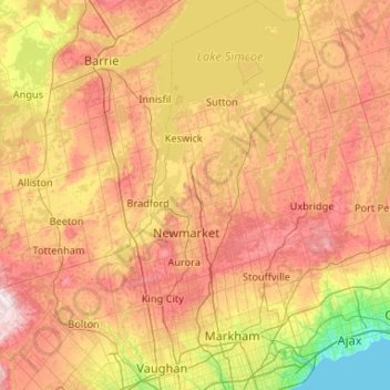
Name: York Region topographic map, elevation, terrain.
Location: York Region, Golden Horseshoe, Ontario, Canada (43.74984 -79.77550 44.50486 -79.15613)
Average elevation: 243 m
Minimum elevation: 73 m
Maximum elevation: 463 m
Ontario trails, hiking, mountain biking, running and outdoor activities
Other topographic maps
Click on a map to view its topography, its elevation and its terrain.
Toronto
Despite its deep ravines, Toronto is not remarkably hilly, but its elevation does increase steadily away from the lake. Elevation differences range from 76.5 metres (251 ft) above sea level at the Lake Ontario shore to 209 m (686 ft) ASL near the York University grounds in the city's north end at the…
Average elevation: 113 m
Guelph
This region of Ontario has cold winters and warm, humid summers, falling into the Köppen climate classification Dfb zone, with moderately high rainfall and snowfall. It is generally a couple of degrees cooler than lower elevation regions on the Great Lakes shorelines, especially so in winter, the exception…
Average elevation: 344 m
Peterborough
Canada > Ontario > Peterborough
Peterborough's topography is largely defined by land formations created by the receding Wisconsian glaciers 10,000–15,000 years ago. The South End and Downtown portions of the City sit on what was the bottom of the glacial Lake Peterborough—part of a glacial spillway created when glacial meltwaters from…
Average elevation: 235 m
London
Canada > Ontario > London > London
London has a humid continental climate (Köppen Dfb), though due to its downwind location relative to Lake Huron and elevation changes across the city, it is virtually on the Dfa/Dfb (hot summer) boundary favouring the former climate zone to the southwest of the confluence of the South and North Thames Rivers,…
Average elevation: 268 m
Alfred
Canada > Ontario > Prescott and Russell Counties > Alfred and Plantagenet
Average elevation: 64 m
Stormy Lake
Canada > Ontario > Parry Sound District > Unorganized Centre Parry Sound
Average elevation: 227 m
Glen Buell
Canada > Ontario > Leeds and Grenville Counties > Elizabethtown-Kitley
Average elevation: 120 m
Trowbridge Island
Canada > Ontario > Thunder Bay District > Unorganized Thunder Bay District
Average elevation: 179 m
Cameron Island
Canada > Ontario > Kenora District > Unorganized Kenora District
Average elevation: 338 m
Arrow Lake
Canada > Ontario > Cochrane District > Unorganized South West Cochrane
Average elevation: 297 m
Why Island
Canada > Ontario > Leeds and Grenville Counties > Leeds and the Thousand Islands
Average elevation: 92 m
Proudfoot Point
Canada > Ontario > Sudbury District > Sables-Spanish Rivers Township
Average elevation: 179 m
Arrow Lake
Canada > Ontario > Nipissing District > Unorganized South Nipissing
Average elevation: 414 m
Dundas
Canada > Ontario > Hamilton > Dundas
Dundas /ˈdʌnˌdæs/ is a community and former town in Hamilton, Ontario, Canada. It is nicknamed the Valley Town because of its topographical location at the bottom of the Niagara Escarpment on the western edge of Lake Ontario. The population has been stable for decades at about twenty thousand, largely…
Average elevation: 171 m
Thistle Lake
Canada > Ontario > Nipissing District > Unorganized South Nipissing
Average elevation: 459 m
Timmus Lake
Canada > Ontario > Thunder Bay District > Unorganized Thunder Bay District
Average elevation: 461 m
Darlington Provincial Park
Canada > Ontario > Durham Region > Clarington
Darlington Provincial Park is a provincial park in Ontario, Canada. It is located just south of Highway 401 in the city of Bowmanville. A small park, the topography is dominated by gentle hills formed by a terminal moraine deposited by glaciers at the end of the last Ice Age. The park borders on the northern…
Average elevation: 84 m
Helmet Lake
Canada > Ontario > Rainy River District > Unorganized Rainy River
Average elevation: 454 m
Webbwood
Canada > Ontario > Sudbury District > Sables-Spanish Rivers Township
Average elevation: 214 m
Arnstein
Canada > Ontario > Parry Sound District > Unorganized Centre Parry Sound
Average elevation: 233 m
Outlet
Canada > Ontario > Leeds and Grenville Counties > Leeds and the Thousand Islands
Average elevation: 97 m