
Why Island topographic map
Click on the map to display elevation.
About this map
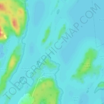
Name: Why Island topographic map, elevation, terrain.
Average elevation: 92 m
Minimum elevation: 84 m
Maximum elevation: 134 m
Other topographic maps
Click on a map to view its topography, its elevation and its terrain.
Seeleys Bay
Canada > Ontario > Leeds and Grenville Counties > Leeds and the Thousand Islands > Seeley's Bay
Average elevation: 105 m
Waterton
Canada > Ontario > Leeds and Grenville Counties > Leeds and the Thousand Islands > Waterton
Average elevation: 97 m
Lansdowne
Canada > Ontario > Leeds and Grenville Counties > Leeds and the Thousand Islands
Average elevation: 101 m
Charleston Lake
Canada > Ontario > Leeds and Grenville Counties > Leeds and the Thousand Islands > Outlet
Average elevation: 103 m
Thousand Islands National Park
Canada > Ontario > Leeds and Grenville Counties > Leeds and the Thousand Islands > Rockport
Average elevation: 116 m
Gananoque Lake
Canada > Ontario > Leeds and Grenville Counties > Leeds and the Thousand Islands
Average elevation: 92 m
Junetown
Canada > Ontario > Leeds and Grenville Counties > Leeds and the Thousand Islands
Average elevation: 110 m
Lyndhurst
Canada > Ontario > Leeds and Grenville Counties > Leeds and the Thousand Islands
Average elevation: 98 m
Seeley's Bay
Canada > Ontario > Leeds and Grenville Counties > Leeds and the Thousand Islands
Average elevation: 106 m
Leeds
Canada > Ontario > Leeds and Grenville Counties > Leeds and the Thousand Islands
Average elevation: 104 m
Outlet
Canada > Ontario > Leeds and Grenville Counties > Leeds and the Thousand Islands
Average elevation: 97 m
Quabbin
Canada > Ontario > Leeds and Grenville Counties > Leeds and the Thousand Islands
Average elevation: 97 m
Rochester Bay
Canada > Ontario > Leeds and Grenville Counties > Leeds and the Thousand Islands
Average elevation: 74 m
Leeds
Canada > Ontario > Leeds and Grenville Counties > Leeds and the Thousand Islands
Average elevation: 104 m
Outlet
Canada > Ontario > Leeds and Grenville Counties > Leeds and the Thousand Islands
Average elevation: 97 m
Seeleys Bay
Canada > Ontario > Leeds and Grenville Counties > Leeds and the Thousand Islands > Seeley's Bay
Average elevation: 105 m