
Make a donation
Gear up for your next adventure:
As an Amazon Associate, this site earns from qualifying purchases at no extra cost to you.
Peel Region topographic map
Click on the map to display elevation.
Make a donation
Gear up for your next adventure:
As an Amazon Associate, this site earns from qualifying purchases at no extra cost to you.
Peel Region
The region's climate are influenced by various air masses and weather systems from other locations, proximity to Lake Ontario, topography and elevation (e.g. Niagara Escarpment, and Oak Ridges Moraine), and urban and rural land uses. The air masses and weather systems are the major factors in influencing the climate of the region. Being located in Southern Ontario, it is located between the Arctic, subtropics, and the Atlantic Ocean; consequentially, it is impacted by air masses from different origins. In general, the air masses that affect the region are continental polar, continental arctic, maritime polar, and occasionally continental tropical air masses in summer. During winter, cold and dry air masses predominate (continental arctic and maritime polar) although warmer, moister air masses may move north during this time, leading to milder temperatures and potential for heavy snowfall/freezing rain/rainfall. The most severe snow and freezing rain events occur when warmer, moister air masses move northward to the region and meet colder air. During winter, a common type of storm is known as the "Alberta Clipper" which affects the region in which moist Pacific air moves east of the Rocky Mountains to the region, bringing snow that is often followed by the influx of cold continental air afterwards (leads to colder temperatures). Spring and autumn are characterized by variable weather and rapid alternating air masses. This leads to frequent cloudy conditions, rain, and occasional thunderstorms. In summer, the air masses that influence the region are predominantly maritime polar air masses from the Pacific Ocean, and tropical air masses from the Gulf of Mexico, the latter being responsible for bringing heat waves, high humidity, and intense rainfall events. Towards late summer and early autumn, the remnants of tropical storms and hurricanes may bring strong winds and heavy rainfalls to the area. During autumn, Arctic air masses become increasingly common, leading to colder conditions.
Make a donation
Gear up for your next adventure:
As an Amazon Associate, this site earns from qualifying purchases at no extra cost to you.
About this map
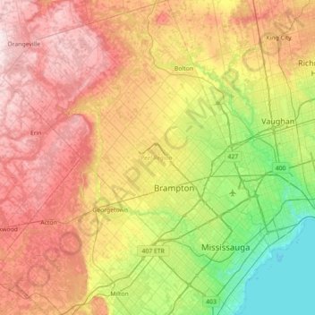
Name: Peel Region topographic map, elevation, terrain.
Location: Peel Region, Golden Horseshoe, Ontario, Canada (43.47899 -80.14426 43.98975 -79.53856)
Average elevation: 265 m
Minimum elevation: 70 m
Maximum elevation: 515 m
Ontario trails, hiking, mountain biking, running and outdoor activities
Make a donation
Gear up for your next adventure:
As an Amazon Associate, this site earns from qualifying purchases at no extra cost to you.
Other topographic maps
Click on a map to view its topography, its elevation and its terrain.
Guelph
This region of Ontario has cold winters and warm, humid summers, falling into the Köppen climate classification Dfb zone, with moderately high rainfall and snowfall. It is generally a couple of degrees cooler than lower elevation regions on the Great Lakes shorelines, especially so in winter, the exception…
Average elevation: 344 m
Toronto
Despite its deep ravines, Toronto is not remarkably hilly, but its elevation does increase steadily away from the lake. Elevation differences range from 76.5 metres (251 ft) above sea level at the Lake Ontario shore to 209 m (686 ft) ASL near the York University grounds in the city's north end at the…
Average elevation: 113 m
London
Canada > Ontario > London > London
London has a humid continental climate (Köppen Dfb), though due to its downwind location relative to Lake Huron and elevation changes across the city, it is virtually on the Dfa/Dfb (hot summer) boundary favouring the former climate zone to the southwest of the confluence of the South and North Thames Rivers,…
Average elevation: 268 m
Frankville
Canada > Ontario > Leeds and Grenville Counties > Elizabethtown-Kitley
Average elevation: 118 m
Make a donation
Gear up for your next adventure:
As an Amazon Associate, this site earns from qualifying purchases at no extra cost to you.
Peterborough
Canada > Ontario > Peterborough
Peterborough's topography is largely defined by land formations created by the receding Wisconsian glaciers 10,000–15,000 years ago. The South End and Downtown portions of the City sit on what was the bottom of the glacial Lake Peterborough—part of a glacial spillway created when glacial meltwaters from…
Average elevation: 235 m
Make a donation
Gear up for your next adventure:
As an Amazon Associate, this site earns from qualifying purchases at no extra cost to you.
Make a donation
Gear up for your next adventure:
As an Amazon Associate, this site earns from qualifying purchases at no extra cost to you.
Make a donation
Gear up for your next adventure:
As an Amazon Associate, this site earns from qualifying purchases at no extra cost to you.
Make a donation
Gear up for your next adventure:
As an Amazon Associate, this site earns from qualifying purchases at no extra cost to you.
Echo River
Canada > Ontario > Algoma District > Macdonald, Meredith and Aberdeen Additional Township
Average elevation: 196 m
Make a donation
Gear up for your next adventure:
As an Amazon Associate, this site earns from qualifying purchases at no extra cost to you.
Dundas
Canada > Ontario > Hamilton > Dundas
Dundas /ˈdʌnˌdæs/ is a community and former town in Hamilton, Ontario, Canada. It is nicknamed the Valley Town because of its topographical location at the bottom of the Niagara Escarpment on the western edge of Lake Ontario. The population has been stable for decades at about twenty thousand, largely…
Average elevation: 171 m
Make a donation
Gear up for your next adventure:
As an Amazon Associate, this site earns from qualifying purchases at no extra cost to you.
Oastler Lake Provincial Park
Canada > Ontario > Parry Sound District > Seguin Township
Average elevation: 218 m
Make a donation
Gear up for your next adventure:
As an Amazon Associate, this site earns from qualifying purchases at no extra cost to you.
Make a donation
Gear up for your next adventure:
As an Amazon Associate, this site earns from qualifying purchases at no extra cost to you.
Dog Lake Narrows
Canada > Ontario > Algoma District > Unorganized North Algoma > Missanabie
Average elevation: 335 m
Make a donation
Gear up for your next adventure:
As an Amazon Associate, this site earns from qualifying purchases at no extra cost to you.
Make a donation
Gear up for your next adventure:
As an Amazon Associate, this site earns from qualifying purchases at no extra cost to you.
Little Boulder Lake
Canada > Ontario > Kenora District > Unorganized Kenora District
Average elevation: 359 m
Make a donation
Gear up for your next adventure:
As an Amazon Associate, this site earns from qualifying purchases at no extra cost to you.
Make a donation
Gear up for your next adventure:
As an Amazon Associate, this site earns from qualifying purchases at no extra cost to you.
Skye Island
Canada > Ontario > Parry Sound District > The Archipelago Township
Average elevation: 191 m
Make a donation
Gear up for your next adventure:
As an Amazon Associate, this site earns from qualifying purchases at no extra cost to you.
Caledonia Springs
Canada > Ontario > Prescott and Russell Counties > The Nation
Average elevation: 51 m
Make a donation
Gear up for your next adventure:
As an Amazon Associate, this site earns from qualifying purchases at no extra cost to you.
Make a donation
Gear up for your next adventure:
As an Amazon Associate, this site earns from qualifying purchases at no extra cost to you.
Little Current
Canada > Ontario > Manitoulin District > Northeastern Manitoulin and the Islands
Average elevation: 193 m
Make a donation
Gear up for your next adventure:
As an Amazon Associate, this site earns from qualifying purchases at no extra cost to you.
Slate Islands
Canada > Ontario > Kenora District > Unorganized Kenora District
Average elevation: 322 m
Make a donation
Gear up for your next adventure:
As an Amazon Associate, this site earns from qualifying purchases at no extra cost to you.
Shabaqua Corners
Canada > Ontario > Thunder Bay District > Unorganized Thunder Bay District
Average elevation: 416 m
Make a donation
Gear up for your next adventure:
As an Amazon Associate, this site earns from qualifying purchases at no extra cost to you.
Watersnake Lake
Canada > Ontario > Cochrane District > Fauquier-Strickland Township
Average elevation: 233 m
Make a donation
Gear up for your next adventure:
As an Amazon Associate, this site earns from qualifying purchases at no extra cost to you.
Make a donation
Gear up for your next adventure:
As an Amazon Associate, this site earns from qualifying purchases at no extra cost to you.
Make a donation
Gear up for your next adventure:
As an Amazon Associate, this site earns from qualifying purchases at no extra cost to you.
Make a donation
Gear up for your next adventure:
As an Amazon Associate, this site earns from qualifying purchases at no extra cost to you.
Waubashene Beaches Provincial Park
Canada > Ontario > Simcoe County > Tay > Waubaushene
Average elevation: 189 m
Make a donation
Gear up for your next adventure:
As an Amazon Associate, this site earns from qualifying purchases at no extra cost to you.
Green Lake
Canada > Ontario > Haliburton County > Dysart et al > West Guilford
Average elevation: 326 m
Make a donation
Gear up for your next adventure:
As an Amazon Associate, this site earns from qualifying purchases at no extra cost to you.