
Kent topographic map
Interactive map
Click on the map to display elevation.
About this map
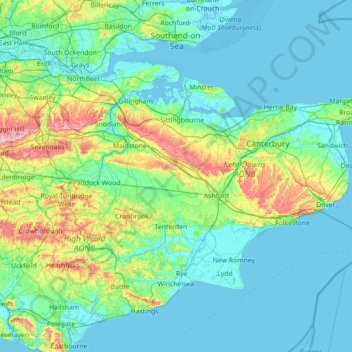
Name: Kent topographic map, elevation, terrain.
Location: Kent, South East, England, United Kingdom (50.91048 0.03352 51.48227 1.45177)
Average elevation: 37 m
Minimum elevation: -3 m
Maximum elevation: 263 m
Kent was also the location of the largest number of art schools in the country during the nineteenth century, estimated by the art historian David Haste, to approach two hundred. This is believed to be the result of Kent being a front line county during the Napoleonic Wars. At this time, before the invention of photography, draughtsmen were used to draw maps and topographical representations of the fields of battle, and after the wars ended many of these settled permanently in the county in which they had been based. Once the idea of art schools had been established, even in small towns in Kent, the tradition continued, although most of the schools were very small one man operations, each teaching a small number of daughters of the upper classes how to draw and make watercolour paintings. Nonetheless, some of these small art schools developed into much larger organisations, including Canterbury College of Art, founded by Thomas Sidney Cooper in 1868, which is today the University for the Creative Arts.
Other topographic maps
Click on a map to view its topography, its elevation and its terrain.
Billingham
United Kingdom > England > Stockton-on-Tees
Billingham, Stockton-on-Tees, Tees Valley, England, United Kingdom
Average elevation: 21 m
Random
United Kingdom > England > Random
Random, Shropshire, West Midlands, England, DY14 0QD, United Kingdom
Average elevation: 347 m
Bucks Green
United Kingdom > England > West Sussex > Horsham
Bucks Green, Horsham, West Sussex, England, RH12 3JN, United Kingdom
Average elevation: 47 m
Weybridge
United Kingdom > England > Surrey > Elmbridge
Weybridge, Elmbridge, Surrey, England, KT13 8RT, United Kingdom
Average elevation: 21 m
Syleham
United Kingdom > England > Suffolk > Mid Suffolk
Syleham, Mid Suffolk, Suffolk, England, United Kingdom
Average elevation: 40 m
Hodge Hill
United Kingdom > England > Birmingham
Hodge Hill, Birmingham, West Midlands Combined Authority, England, B36 8EG, United Kingdom
Average elevation: 101 m
Bawsey
United Kingdom > England > Norfolk > King's Lynn and West Norfolk
Bawsey, King's Lynn and West Norfolk, Norfolk, England, United Kingdom
Average elevation: 16 m
Rotherham
Rotherham, South Yorkshire, England, United Kingdom
Average elevation: 101 m
Stockton-on-the-Forest
United Kingdom > England > York
Stockton-on-the-Forest, York, England, United Kingdom
Average elevation: 22 m
Waddington
United Kingdom > England > Lancashire > Ribble Valley
Waddington, Ribble Valley, Lancashire, England, United Kingdom
Average elevation: 164 m
St Helens
St Helens, Liverpool City Region, England, United Kingdom
Average elevation: 49 m
Blackburn
United Kingdom > England > Blackburn with Darwen
Blackburn, Blackburn with Darwen, England, BB1 7DP, United Kingdom
Average elevation: 157 m
London
United Kingdom > England > London
London, Westminster, England, SW1A 2DX, United Kingdom
Average elevation: 42 m
Walton-on-Thames
United Kingdom > England > Surrey
Walton-on-Thames, Surrey, England, United Kingdom
Average elevation: 17 m
Nuneaton and Bedworth
United Kingdom > England > Warwickshire
Nuneaton and Bedworth, Warwickshire, England, United Kingdom
Average elevation: 108 m
Warmley
United Kingdom > England > South Gloucestershire
Warmley, Siston, South Gloucestershire, West of England, England, BS15 4PP, United Kingdom
Average elevation: 69 m
Bury St Edmunds
United Kingdom > England > Suffolk > West Suffolk
Bury St Edmunds, West Suffolk, Suffolk, England, United Kingdom
Average elevation: 54 m
Shepton Mallet
United Kingdom > England > Somerset
Shepton Mallet, Somerset, England, United Kingdom
Average elevation: 173 m
Wadhurst
United Kingdom > England > East Sussex > Wealden
Wadhurst, Wealden, East Sussex, England, United Kingdom
Average elevation: 109 m
Brabourne Lees
United Kingdom > England > Kent > Ashford
Brabourne Lees, Ashford, Kent, England, TN25 6QG, United Kingdom
Average elevation: 73 m
Trowbridge
United Kingdom > England > Wiltshire
Trowbridge, Wiltshire, England, United Kingdom
Average elevation: 47 m
Upper Tean
United Kingdom > England > Staffordshire > Staffordshire Moorlands
Upper Tean, Staffordshire Moorlands, Staffordshire, England, ST10 4EH, United Kingdom
Average elevation: 175 m
Packmoor
United Kingdom > England > Stoke-on-Trent
Packmoor, Stoke-on-Trent, England, ST7 4SW, United Kingdom
Average elevation: 194 m
Winterborne Monkton
United Kingdom > England > Dorset
Winterborne Monkton, Dorset, England, United Kingdom
Average elevation: 92 m
Esher
United Kingdom > England > Surrey > Elmbridge
Esher, Elmbridge, Surrey, England, United Kingdom
Average elevation: 21 m
Berwick St. John
United Kingdom > England > Wiltshire
Berwick St. John, Wiltshire, England, United Kingdom
Average elevation: 168 m
Silbury Hill
United Kingdom > England > Wiltshire > Beckhampton
Silbury Hill, Silbury Cottages, Beckhampton, Avebury, Wiltshire, England, United Kingdom
Average elevation: 166 m
Baldock
United Kingdom > England > Hertfordshire > North Hertfordshire
Baldock, North Hertfordshire, Hertfordshire, England, SG7 6AS, United Kingdom
Average elevation: 90 m
Woodlands Road
United Kingdom > England > Staffordshire > Stafford
Woodlands Road, Stafford, Staffordshire, England, United Kingdom
Average elevation: 85 m
Steep
United Kingdom > England > Hampshire > East Hampshire > Steep
Steep, East Hampshire, Hampshire, England, United Kingdom
Average elevation: 115 m
Orway
United Kingdom > England > Devon > Mid Devon > Saint Hill
Orway, Kentisbeare, Saint Hill, Mid Devon, Devon, England, EX15 2EX, United Kingdom
Average elevation: 155 m
Garsdale
United Kingdom > England > Westmorland and Furness > Sedbergh
Garsdale, Sedbergh, Westmorland and Furness, England, United Kingdom
Average elevation: 361 m
Elmbridge
United Kingdom > England > Surrey
Elmbridge, Surrey, England, United Kingdom
Average elevation: 29 m
Darfield
United Kingdom > England > Barnsley
Darfield, Barnsley, South Yorkshire, England, S73 9AB, United Kingdom
Average elevation: 43 m
Coxhoe
United Kingdom > England > County Durham
Coxhoe, County Durham, North East, England, United Kingdom
Average elevation: 111 m
Abingdon
United Kingdom > England > Oxfordshire > Vale of White Horse
Abingdon, Vale of White Horse, Oxfordshire, England, OX14 3UJ, United Kingdom
Average elevation: 64 m
Plaxtol
United Kingdom > England > Kent > Tonbridge and Malling
Plaxtol, Tonbridge and Malling, Kent, England, United Kingdom
Average elevation: 100 m
Bournemouth
United Kingdom > England > Bournemouth, Christchurch and Poole > Kinson
Bournemouth, Kinson, Bournemouth, Christchurch and Poole, England, United Kingdom
Average elevation: 17 m
Chapel-en-le-Frith
United Kingdom > England > Derbyshire > High Peak
Chapel-en-le-Frith, High Peak, Derbyshire, England, United Kingdom
Average elevation: 324 m
Meopham
United Kingdom > England > Kent > Gravesham
Meopham, Gravesham, Kent, England, United Kingdom
Average elevation: 124 m
Frant
United Kingdom > England > East Sussex > Wealden > Bells Yew Green
Frant, Bells Yew Green, Wealden, East Sussex, England, United Kingdom
Average elevation: 111 m
London
London, Greater London, England, United Kingdom
Average elevation: 66 m
Eynsford
United Kingdom > England > Kent > Sevenoaks
Eynsford, Sevenoaks, Kent, England, United Kingdom
Average elevation: 104 m
Willenhall
Willenhall, Walsall, West Midlands Combined Authority, England, WV13 1PU, United Kingdom
Average elevation: 143 m
Walmer
United Kingdom > England > Kent > Dover
Walmer, Dover, Kent, England, United Kingdom
Average elevation: 12 m
Bulwell
United Kingdom > England > Nottingham
Bulwell, Nottingham, England, NG6 8QA, United Kingdom
Average elevation: 84 m
Aldridge
Aldridge, Walsall, West Midlands Combined Authority, England, WS9 8QP, United Kingdom
Average elevation: 144 m
Ticehurst
United Kingdom > England > East Sussex > Rother
Ticehurst, Rother, East Sussex, England, United Kingdom
Average elevation: 81 m
Sevenoaks
United Kingdom > England > Kent > Sevenoaks
Sevenoaks, Kent, England, United Kingdom
Average elevation: 127 m