Geolocate

Shepton Mallet topographic map

Click on the map to display elevation.

About this map

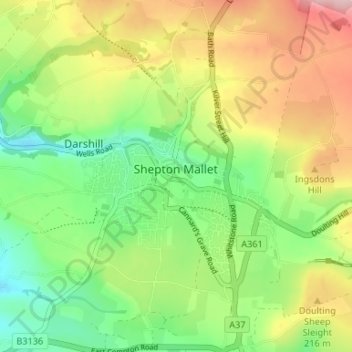
Name: Shepton Mallet topographic map, elevation, terrain.

Location: Shepton Mallet, Somerset, England, United Kingdom (51.16938 -2.57986 51.21084 -2.52008)

Average elevation: 173 m

Minimum elevation: 87 m

Maximum elevation: 294 m

Other topographic maps

Click on a map to view its topography, its elevation and its terrain.

Charlton Mackrell

United Kingdom > England > Somerset

Average elevation: 42 m

Ludney

United Kingdom > England > Somerset > Kingstone

Average elevation: 89 m

Highbridge

United Kingdom > England > Somerset > Sedgemoor > Highbridge

Average elevation: 6 m

Burnham-on-Sea

United Kingdom > England > Somerset > Sedgemoor

Average elevation: 5 m

Draycott

United Kingdom > England > Somerset > Mendip District > Draycott

Average elevation: 86 m

Gear up for your next adventure:

💡Solar Camping Lamp - Eco-friendly lighting for campsites
🧤Insulated Winter Gloves - Heavy-duty protection for sub-zero Canadian adventures
Bushcraft Tarp - Versatile emergency shelter or gear protection
🧦Crew Hiking Socks - Comfortable socks for long-distance hikes
🥘Camping Cookware Set - Compact nesting pots and pans for trail cooking

As an Amazon Associate, this site earns from qualifying purchases at no extra cost to you.