
Tandövala topographic map
Interactive map
Click on the map to display elevation.
About this map
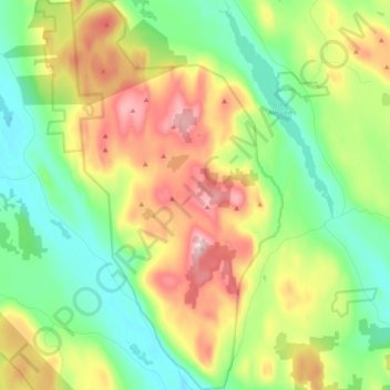
Name: Tandövala topographic map, elevation, terrain.
Location: Tandövala, Malung-Sälens kommun, Dalecarlia, Sweden (60.80145 13.10893 60.89866 13.21643)
Average elevation: 555 m
Minimum elevation: 429 m
Maximum elevation: 770 m
Other topographic maps
Click on a map to view its topography, its elevation and its terrain.
Abisko
Permafrost is common around the village albeit this low altitude permafrost is disappearing because of global warming and increased snowfall.
Average elevation: 395 m
Province of Södermanland
The terrain is flat, with its highest altitude being Skogsbyås at 124 m (407 ft) elevation. The terrain largely consists of water filled hollows covered with woods on the heights.
Average elevation: 23 m
Uppsala
Situated on the fertile Uppsala flatlands of muddy soil, the city features the small Fyris River (Fyrisån) flowing through the landscape surrounded by lush vegetation. Parallel to the river runs the glacial ridge of Uppsalaåsen at an elevation around 30 m (98 ft), the site of Uppsala's castle, from which…
Average elevation: 29 m
Jönköping
Jönköping's climate was humid continental (Köppen Dfb) with long, cold winters and short, warm summers during the 1961–1990 period. However, the window between subarctic and oceanic is very small in this marine-influenced climate type, and in recent years the climate has more resembled very cold oceanic.…
Average elevation: 215 m