Geolocate

Lagan topographic map

Click on the map to display elevation.

About this map

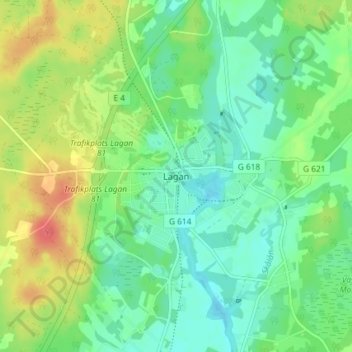
Name: Lagan topographic map, elevation, terrain.

Location: Lagan, Ljungby kommun, Kronoberg County, 341 51, Sweden (56.89746 13.96947 56.93746 14.00947)

Average elevation: 152 m

Minimum elevation: 134 m

Maximum elevation: 184 m

Gear up for your next adventure:

🔭Compact Binoculars - Lightweight optics for scouting trails and wildlife
🪑Ultralight Camping Stool - Compact seating for rest stops during long hikes
🧊Portable Cooler - Keep food and drinks cold during outdoor adventures
🔦LED Headtorch - Bright and durable light for night activities
🥾Lightweight Hiking Shoes - Comfortable shoes for day hikes

As an Amazon Associate, this site earns from qualifying purchases at no extra cost to you.